Geography of the North Cascades

The geography of the North Cascades describes a range of rugged mountains in British Columbia, Canada and Washington, United States.

[1]: 17  Sometimes the southern boundary is defined by Snoqualmie Pass and the approximate route of Interstate 90.

Designated wilderness areas in the range include: In British Columbia, protected areas include The following North Cascades peaks are notable for their height (absolute elevation): (The above table uses a topographic prominence cutoff of 1,000 feet (300 m), in order to list only highly independent peaks.)

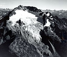
[4] Many tall waterfalls occur where meltwater from mountain glaciers drop down a headwall, which are common occurrences in the North Cascades.

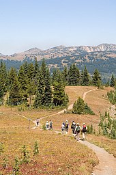
Geographical features in the area of the North Cascades National Park can be found in this image map:

A group of hikers in E.C. Manning Provincial Park .
Hozomeen Mountain from Hozomeen Lake
Heinrich C. Berann Ross Lake Seattle Olympic National Park Mount Rainier National Park Lake Chelan Diablo Lake Mount Shuksan - 9,131 ft Mount Baker - 10,775 ft Hozomeen Mountain - 8,068 ft Goode Mountain - 9,206 ft Mount Logan - 9,074 ft Eldorado Peak - 8,672 ft Luna Peak - 8,311 ft Picket Range Twin Sisters Mountain - 7,020 ft
Painting of North Cascades Nat'l Park by Heinrich C. Berann. Aerial view of the entire park from the east, looking west. Ross Lake is in the foreground, drained by the Skagit River flowing toward Puget Sound and the Strait of Juan de Fuca in the background. Mount Baker is prominently visible on the upper right with Glacier Peak and Mount Rainier the prominent peaks in the upper left background and the Olympic Mountains the dark massif in the background of the upper centre. Mouse over the picture and click on an area of interest.