Geology of Australia
Recent geologic events are confined to intraplate earthquakes, as the continent of Australia sits distant from the plate boundary.
The Australian landmass has been part of all major supercontinents, but its association with Gondwana is especially notable as important correlations have been made geologically with the African continental mass and Antarctica.
Continental Australia is unique among the continents in that the measured stress field is not parallel to the present-day north-northeast directed plate motion.
Most of the stress state in continental Australia is controlled by compression originating from the three main collision boundaries located in New Zealand, Indonesia and New Guinea, and the Himalaya (transmitted through the Indian and Capricorn plates).
Notably, the main stress trajectories diverge most markedly from one another in north–central New South Wales (east-southeast to north-northeast), although the area is not known historically for earthquake activity.
Young mountain building (< 5 Ma) in the Flinders Ranges of South Australia is driven from plate convergence at the boundary in New Zealand.
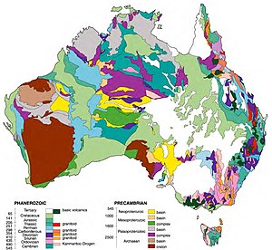
Chiefly the Glenburgh Orogeny is partly responsible for the assembly of the West Australian landmass by joining the Yilgarn and Pilbara cratons.
The Petermann Orogeny caused extensive uplift, mountain building and basin fragmentation in central Australia at the close of the Neoproterozoic.
The extensive Antrim Plateau flood basalts, covering in excess of 12,000 square kilometres, erupt in the Cambrian of Western Australia, providing a useful chronostratigraphic marker.
Victoria – 490–440 Ma The late Cambrian to early Ordovician saw deepwater sedimentation of the St Arnaud and Castlemaine Group turbidites, which are now emplaced in the Stawell and Bendigo Zones.
Near Kalbarri on the Murchison River the footprints of a giant water scorpion were found on land, the first animal to walk on the Australian continent.
Andesite and Rhyolite volcanoes were found in central NSW, the Snowy Mountains, Eden, New England and near Clermont, Queensland.
The Tabberabberan Orogeny compressed the eastern seaboard in an east–west direction, with Tasmania, Victoria and southern New South Wales folded 385 – 380 Mya.
[2] The Carboniferous Period saw the Eastern Highlands of Australia form as a result of its collision with what are now parts of South America (e.g. the Sierra de Cordoba) and New Zealand.
Evidence for the cold conditions can be seen not only in glacial features dating from this period but also in fossil Gelisols from as far north as the Hunter River basin.
The Permian to Triassic in Australia is dominated by subduction zones on the eastern margin of the landmass, part of the Hunter-Bowen Orogeny.
This was a major arc-accretion, subduction and back-arc sedimentary basin forming event which persisted episodically from approximately late Carboniferous in its initial stages, through the Permian and terminated in the Middle Triassic at around 229Ma to 225Ma.
Petroleum was formed in the Swan Coastal Plain and Pilbara during this rifting, presumably in a rift valley lake where the bottom was deoxygenated (akin to Africa's Lake Tanganyika today) See also: In the west of Australia the Jurassic was a tropical savannah to jungle environment, shown by advanced tropical weathering preserved in the regolith of the Yilgarn craton which is still preserved today.
The Prospect dolerite intrusion in the Sydney Basin was a result of tense continental crust breaking all the way down to the upper mantle during development of the rift divergence zone that occurred before the breakup of the Australian and Antarctic continents in the Eocene epoch.
See also The initial rifting of Australia and Antarctica in the Jurassic continued through the Cretaceous, with offshore development of a mid ocean ridge seafloor spreading centre.