Geology of Saskatchewan
[MapA][5] The Earth was experiencing hotter and more volatile Archean tectonics, evidencing island arc volcanic activity and mountain building.
It lies in the central portion of the Trans-Hudson Orogeny and was formed by arc volcanism during the Paleoproterozoic Era.
[16][dead link] The Athabasca basin was formed during the Statherian or Paleohelikian 1.7 to 1.6 billion years ago when coarse fluvial and marine clastic sediments were laid down containing gold, copper, lead, zinc, and uranium oxides.
[5][17] The highest-grade uranium deposits in the world are found at the unconformity between these clastic layers and the Precambrian bedrock.
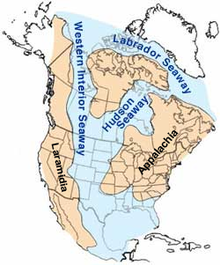
There were three depositional stages for the Western Canada Sedimentary Basin which were dependent on plate tectonics of the era.
Re-flooding in the Late Ordovician age with warm water increased calcium carbonate sedimentation, and marine life.
The Williston basin was formed creating a lowered land area during this period filling with the Winnipeg Sea.
The orogeny between Laurasia and Gondwana created the Appalachian Mountains, and an exodus of water from the Laurasian land surface.
[5][21] The Cretaceous period rocks produce medium and heavy gravity oil in the Lloydminster region, and of the western province.
[21] The Laramide orogeny episode near the end of the Cretaceous and early Tertiary period caused larger gravels to be deposited from the newly formed Rocky Mountains when the Kula and Farallon Plates subducted below the North American Plate.
[26] In the Cypress Hills area and southern Saskatchewan, lignite deposits developed from the marshes of these Tertiary rivers.
Tectonic movements and global changes in the sea level have given rise to a source of oil, natural gas, and coal.
During the Quaternary period, between 2 and 3 million years ago, the prairies were covered by a glacier, the Laurentide Ice Sheet.
There were multiple glaciations affecting the Saskatchewan area during the Pre-Illinoian, Illinoian, and Wisconsin stages of the last ice age.
[28]: 142 By the study of till, terrain, the limits of the Illinoian glaciation are evidenced around Willow Bunch Lake, Wood Mountain, Cypress Hills area.
Between the Alberta and Saskatchewan Plains is the Missouri Coteau, dead ice moraine, a major escarpment, a long meandering ridge of hill country.
Carswell, Deep Bay, and Gow Lake have affected the Canadian Shield area of the north.
[33] It is estimated that the impact to the Athabasca basin occurred about 478 million years ago during the Ordovician period.
The William River Subgroup and the Douglas and Carswell formations show inversions, thrusting and disruptions.
The circular impact ridge 100 metres (330 ft) above water level partially encompasses the crater area.
This impact affected Upper Cretaceous Bearpaw Formation sediments on the north edge of the Cypress Hills, and roughly occurred 75 million years ago.
[36] The crater is located in Maple Bush rural municipality north of Aitkow (Riverhurst) and west of Grainfield (Grainland).