Volcanism of Canada
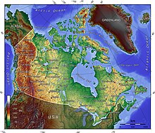
[3] Even so, the mountainous landscapes of the Canadian provinces of Alberta, British Columbia, Yukon, and the Northwest Territories include more than 100 volcanoes that have been active during the past two million years and whose eruptions have claimed many lives.
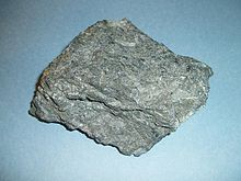
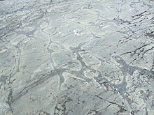
[4] The most capable large igneous provinces in Canada are Archean greenstone belts estimated at 3.8 to 2.5 billion years old, containing a rare volcanic rock called komatiite.
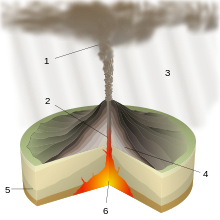
[6][7][8][9] For example, geologists have identified at least 30 young cinder cones on the Mount Edziza volcanic complex, a large shield volcano in northwestern British Columbia with an area of 1,000 square kilometres (390 sq mi).
[46] This supercontinent began to fracture 220 million years ago when the Earth's lithosphere was being pulled apart from extensional stress, creating a divergent plate boundary known as the Fundy Basin.
[48] The Fogo Seamounts, located 500 km (311 mi) offshore of Newfoundland to the southwest of the Grand Banks, consists of submarine volcanoes with dates extending back to the Early Cretaceous period at least 143 million years ago.
[49] The Flin Flon greenstone belt in central Manitoba and east-central Saskatchewan is a collage of deformed volcanic arc rocks ranging in age from 1,904 to 1,864 million years old during the Paleoproterozoic sub-division of the Precambrian eon.
[54] The Canadian portion of the Pacific Northwest began forming during the early Jurassic period when a group of active volcanic islands collided against a pre-existing continental margin and coastline of Western Canada.
[55] Magma rising from the Omineca Arc successfully connected the Intermontane Belt to the mainland of Western Canada, forming a chain of volcanoes in British Columbia that existed discontinuously for about 60 million years.
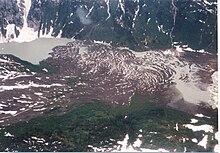
[62][63] The roughly circular, 20 kilometres (12 mi) wide, deeply dissected Silverthrone Caldera in the northern segment of the Garibaldi Volcanic Belt, was formed one million years ago during the Early Pleistocene period.
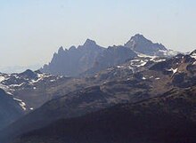
[3] The Mount Meager massif, the most persistent volcano in the northern portion of the Garibaldi Volcanic Belt, is a complex of at least four overlapping stratovolcanoes made of dacite and rhyodacite that become progressively younger from south to north, ranging in age from two million to 2,490 years old.
[3] Mount Cayley, the largest and most persistent volcano, is a deeply eroded stratovolcano comprising a lava dome complex made of dacite and minor rhyodacite ranging in age from 3.8 to 0.31 million years old.
[3] Mount Garibaldi, a fairly dissected stratovolcano 80 kilometres (50 mi) north of Vancouver, was built by Peléan eruptions between 0.26 and 0.22 million years ago during the waning stages of the last glacial, or "Wisconsinian", period.
[3] Volcanoes within the British Columbia portion of the Northern Cordilleran Volcanic Province are disposed along short, northerly trending en-echelon segments which, in the British Columbia portion of the volcanic province, are unmistakably involved with north-trending rift structures including synvolcanic grabens and half-grabens similar to the East African Rift, which extends from the Afar triple junction southward across eastern Africa.
[3] The Northern Cordilleran rift system formed as a result of the North American continent being stretched by extensional forces as the Pacific Plate slides northward along the Queen Charlotte Fault to the west, on its way to the Aleutian Trench, which extends along the southern coastline of Alaska and the adjacent waters of northeastern Siberia off the coast of Kamchatka Peninsula.
[3] A region of continental rifting, such as the Northern Cordilleran Volcanic Province, would support the development of high-level reservoirs of sufficient size and thermal capacity to sustain prolonged fractionation.
[3] The Explorer Ridge, an underwater mountain range lying 160 kilometres (99 mi) west of Vancouver Island on the Coast of British Columbia, consists of a north-south trending rift zone.
[68] In contrast, the Northern Explorer Ridge has evolved into a complex compound structure consisting of several rift basins bounded by half-graben and arcuate shaped faults with a superimposed pattern of rhombohedral grabens and horsts.
[70] The manned United States Navy deep-ocean research submersible DSV Alvin and the remotely operated underwater vehicle Jason have done work at the Endeavor Hydrothermal Vents.
[71] The lowermost lavas were produced by melting in the garnet stability field below the surface at a depth of more than 90 kilometres (56 mi) in a mantle plume environment beneath the North American lithosphere.
[71] During the Early Jurassic period 196 million years ago, the New England or Great Meteor hotspot existed in the Rankin Inlet area of southern Nunavut along the northwestern coast of Hudson Bay, producing kimberlite magmas.
[73] Widespread basalt volcanism occurred between 60.9 and 61.3 million years ago in the northern Labrador Sea, Davis Strait and in southern Baffin Bay on the eastern coast of Nunavut during the Paleocene period when North America and Greenland were being separated from tectonic movements.
[3] This volcanic belt lies largely in the U.S. state of Alaska, but extends across the Alaska-Yukon border into southwestern Yukon where it contains scattered remnants of subaerial lavas and pyroclastic rocks which are preserved along the entire eastern fringe of the ice covered Saint Elias Mountains.
[75] Native American legends about the area indicate the final eruption from Mount Churchill 1,250 years ago disrupted food supplies and forced them to move further south.
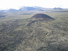
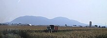
[20] Ne Ch'e Ddhawa, a cinder cone 2 kilometres (1.2 mi) away from the connection of the Yukon and Pelly rivers formed between 0.8 and one million years ago when this area lied beneath the vast Cordilleran Ice Sheet.
[4] The 2,217- to 2,210-million-year-old Ungava magmatic event was the source for the Nipissing sills of Ontario and have been historically important for copper, silver, and arsenic mineralization, and also have the potential to contain platinum group metals.
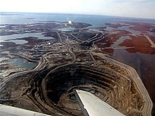
55–50 Ma) age diatremes of the Lac de Gras kimberlite field in the central Slave craton of the Northwest Territories support two world-class diamond mines, called Ekati and Diavik.
[93] This activity produced a diverse sequence of volcanic deposits, well exposed in bluffs along the 209 kilometres (130 mi) long Lillooet River, which are grouped as part of the Pebble Creek Formation.
[94] The explosive power associated with this Plinian eruption sent an ash column estimated to have risen at least 20 kilometres (12 mi) above Meager, indicating it entered the second major layer of the Earth's atmosphere.
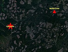
[128] A series of earthquakes of less than magnitude 3.0 were recorded by seismographs in the Baezaeko River region 20 kilometres (12 mi) west of Nazko Cone in the Anahim Volcanic Belt on October 9, 2007.
For example, The Barrier, an unstable lava dam retaining the Garibaldi Lake system of southwestern British Columbia, has in the past unleashed several debris flows, most recently in 1855–1856.