Geology of the Cairngorms National Park
The majority of the rocks within the National Park belong to the Dalradian Supergroup, a thick sequence of sands, muds and limestones that were deposited between about 800 and 600 million years ago on the margins of the former continent of Laurentia.
The subsequent collision of Baltica with Laurentia caused the ‘Scandian event’ which involved further folding and faulting of the Dalradian rock sequence.
[3] The largest of these plutons is the granite mass which forms the Cairngorms themselves and which was emplaced around 427 million years ago.
The Markie Gneiss is a unit of micaceous psammite within fault-bounded blocks on the western margin of the National Park.
[4] The oldest rocks within the area are those of the Tonian age Badenoch Group,[5] which occur along the northwestern edge of the national park.
The latter may rest unconformably on the Glen Banchor rocks or else the relationship may be wholly tectonic in nature i.e. faulted or sheared.
They are a complex mix of psammites, phyllites, pelites, semipelites, quartzites and meta-limestones and other lithologies originally laid down as marine sand, mud, silt etc.
[11] Overlying these are the rocks of the Corrieyairick Subgroup which are thought to have originally been turbidites and represent a time of rifting and basin development.
The subgroup includes the Tom na Fianaig, Fodderletter Calcareous Flag, Riabhach Banded and Dalvrecht Slate formations.
The Islay Subgroup is the oldest/lowermost division of the group and includes the Kymah Quartzite, Auchnahyle, Ladder Hills and Nochty Semipelite and Limestone formations.
No solid rocks of late Devonian or succeeding periods are recorded within the area of the National Park.
Numerous plutons were emplaced within the Dalradian sequence at the close of the Caledonian Orogeny from late Silurian to early Devonian times.
[20] The Mount Battock pluton is of a similar size but only the western portion of it falls within the national park.
The similarly aligned Loch Tay Fault is a major landscape-forming feature running through the centre of the Park.
It is mapped along the length of the notably straight Glen Tilt, passing out of the Park immediately west of Blair Atholl, en route for the Highland border via the central alignment of the loch which gives it its name.
It defines the eastern margin of the Cairngorm pluton before running into Glen Builg at its northeastern end.
The Bridge of Garry-Loch Balgie Fault is a third member of this group entering the Park from the southwest in the vicinity of Dalnaspidal Lodge.
On the eastern margins of the Monadhliath are Lochan a Choire beneath Geal Charn and Loch Dubh.
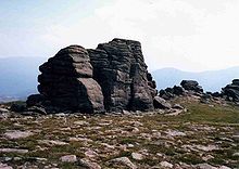
Tors are a common feature of the Cairngorm granite massif, being especially frequent on Ben Avon and Beinn Mheadhoin and impressively high on Bynack More.