Geology of the Grand Canyon area
Uplift of the region started about 75 million years ago during the Laramide orogeny; a mountain-building event that is largely responsible for creating the Rocky Mountains to the east.
The end of the last ice age and subsequent human activity has greatly reduced the ability of the Colorado River to excavate the canyon.
At about 2.5 and 1.8 billion years ago in Precambrian time, sand, mud, silt, and ash were laid down in a marine basin adjacent to an orogenic belt.
As the volcanic islands collided with the mainland around 1.7 billion years ago, blobs of magma rose from the subduction zone and intruded the Granite Gorge Metamorphic Suite.
[6] Eventually, this sunken region of Laurentia was flooded with a shallow seaway that extended from at least present-day Lake Superior to Glacier National Park in Montana to the Grand Canyon and the Uinta Mountains.
[3] The resulting Grand Canyon Supergroup of sedimentary units is composed of nine varied geologic formations that were laid down from 1.2 billion and 740 million years ago in this sea.
[10] Dox Formation is over 3,000 feet (910 m) thick and is made of sandstone with some interbedded shale beds and mudstone that were deposited in fluvial and tidal environments.
[27] As its shoreline moved east, river profiles rose and fluvial sediments accumulated within tectonic basins and coastal plains at first as the Sixtymile Formation, a tan-colored sandstone with some small layers of shale.
As sea level rose, the ocean flooded the coastal plain causing the concurrent deposition of the Tapeats Sandstone, Bright Angel Shale, Muav Limestone, and Frenchman Mountain Dolostone.
[27][28] Tapeats Sandstone averages 525 million years old and is made of medium- to coarse-grained sand and conglomerate that was deposited on an ancient shore (see 3a in figure 1).
The Bright Angel Shale in the group forms an aquiclude (barrier to groundwater seeping down), and thus collects and directs water through the overlying Muav Limestone to feed springs in the Inner Gorge.
[39] Many fossilized crinoids, brachiopods, bryozoans, horn corals, nautiloids, and sponges, along with other marine organisms such as large and complex trilobites have been found in the Redwall.
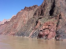
[34] Surprise Canyon Formation is a sedimentary layer of purplish-red shale that was laid down in discontinuous beds of sand and lime above the Redwall (see 4c in figure 1).
It was created in very late Mississippian and possibly in very earliest Pennsylvanian time as the land subsided and tidal estuaries filled river valleys with sediment.
[41] Both marine and non-marine deposits of mud, silt, sand and calcareous sediments were laid down on a broad coastal plain similar to the Texas Gulf Coast of today.
[41] Around this time, the Ancestral Rocky Mountains rose in Colorado and New Mexico and streams brought eroded sediment from them to the Grand Canyon area.
[43] Formations of the Supai Group are from oldest to youngest (an unconformity is present at the top of each): Watahomigi (see 5a in figure 1) is a slope-forming gray limestone with some red chert bands, sandstone, and purple siltstone that is 100 to 300 feet (30 to 90 m) thick.
[41] The alternating thin-bedded iron oxide, mud and silt were deposited via freshwater streams in a semiarid environment around 280 million years ago.
[50] Cross bedding patterns of the frosted, fine-grained, well-sorted and rounded quartz grains seen in its cliffs is compatible with but does not substantiate conclusively an eolian environment.
It erodes into ledgy cliffs that are 300 to 400 feet (90 to 100 m) thick[55] and was laid down in latest early Permian time, about 270 million years ago,[11] by an advancing warm, shallow sea.
Shark teeth have been found in this formation as well as abundant fossils of marine invertebrates such as brachiopods, corals, mollusks, sea lilies, and worms.
Streams flowing through broad low valleys in Triassic time deposited sediment eroded from nearby uplands, creating the once 1,000-foot (300 m)-thick Moenkopi Formation.
[57] Formations totaling over 4,000 to 5,000 feet (1,200 to 1,500 m) in thickness were deposited in the region in the Mesozoic and Cenozoic but were almost entirely removed from the Grand Canyon sequence by subsequent erosion.
[61] Streams draining the Rocky Mountains in early Miocene time terminated in landlocked basins in Utah, Arizona and Nevada but there is no evidence for a major river.
[62] Around 18 million years ago, tensional forces started to thin and drop the region to the west, creating the Basin and Range Province.
[63][note 2] The extreme western part of the canyon ends at one of the Basin and Range faults, the Grand Wash, which also marks the boundary between the two provinces.
[43] Uplift from the Laramide orogeny and the creation of the Basin and Range province worked together to steepen the gradient of streams flowing west on the Colorado Plateau.
These streams cut deep, eastward-growing, channels into the western edge of the Colorado Plateau and deposited their sediment in the widening Basin and Range region.
[62] At the same time, streams flowed from highlands in central Arizona north and across what is today the western Grand Canyon, possibly feeding a larger river.
The museum building, the historic Yavapai Observation Station (built 1928), located one mile (1.6 km) east of Market Plaza, features expansive canyon views.