Geology of the United States
Over the 4.5 billion-year history of the Earth, tectonic upheavals and colliding plates have raised great mountain ranges while the forces of erosion and weathering worked to tear them down.
Even after many millions of years, records of Earth's great upheavals remain imprinted as textural variations and surface patterns that define distinctive landscapes or provinces.
The plate tectonic history of a region strongly influences the rock type and structure exposed at the surface, but differing rates of erosion that accompany changing climates can also have profound impacts on the land.
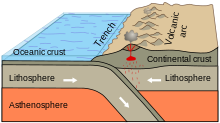
[2] The Pacific Province straddles the boundaries between several of Earth's moving plates:the source of the monumental forces required to build the sweeping arc of mountains that extends from Alaska to the southern reaches of South America.
This province includes the active and sometimes deadly volcanoes of the Cascade Range and the young, steep mountains of the Pacific Border and the Sierra Nevada.
By a few tens of millions of years ago, so much of the upper part had worn away that the surface of the ancient range had a low relief of just a few thousand feet.
The Cascades Province forms an arc-shaped band extending from British Columbia to Northern California, roughly parallel to the Pacific coastline.
As the oceanic slab sinks deep into the Earth's interior beneath the continental plate, high temperatures and pressures allow water molecules locked in the minerals of solid rock to escape.
Looking like a great spoon scooped out the Earth surface, the smooth topography of this province forms a striking contrast with the strong mountainous fabric around it.
Calderas, great pits formed by explosive volcanism, and low shield volcanoes, and rhyolite hills are also part of the landscape here, but many are obscured by later lava flows.
Evidence suggests that some concentrated heat source is melting rock beneath the Columbia Plateau Province, at the base of the lithosphere (the layer of crust and upper mantle that forms Earth's moving tectonic plates).
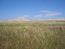
The Great Basin is the geographical and hydrological region comprising most of Nevada, southern Oregon and Idaho, western Utah, and a little of eastern California.
The extent of internal drainage, the area in which surface water cannot reach the ocean, defines the geographic region called the Great Basin.
This internally-drained area occupies approximately 200,000 square miles (520,000 km2), including most of Nevada, a large part of Utah, and portions of Idaho, California, and Oregon.
This is a vast region of plateaus, mesas, and deep canyons whose walls expose rocks ranging in age from billions to just a few hundred years old.
Most are metamorphic rocks formed deep within the Earth while continental collision on a grand scale produced the nucleus of the North American continent well over a billion years ago.
Igneous rocks injected millions of years later form a marbled network through parts of the Colorado Plateau's darker metamorphic basement.
The Rocky Mountains took shape during a period of intense plate tectonic activity that formed much of the rugged landscape of the western United States.
Western North America suffered the effects of repeated collision as slabs of ocean crust sank beneath the continental edge.
The basement rocks of the Laurentian Upland Province were metamorphosed about 2500 million years ago in a mountain-building collision of tectonic plates called the Kenoran Orogeny.
During the Late Wisconsin, the last glaciation of the Pleistocene Epoch, a massive continental ice sheet grew first in the north, then gradually expanded southward.
When the continental ice sheets melt, they left behind an assortment of rock called glacial drift that covers much of the Superior Upland landscape.
With the exception of the Black Hills of South Dakota, the entire region has low relief, reflecting more than 500 million years of relative tectonic stability.
[16] Throughout the Paleozoic and Mesozoic Eras the mostly low-lying Interior Plains region remained relatively unaffected by the mountain-building tectonic collisions suffered by the western and eastern margins of the continent.
[18] During the middle Ordovician Period (about 440–480 million years ago), a change in plate motions set the stage for the first Paleozoic mountain building event (Taconic orogeny) in North America.
The massive bulk of Pangea was completed near the end of the Paleozoic Era (Permian Period) when Africa (Gondwana) plowed into the continental agglomeration, with the Appalachian-Ouachita mountains near the core.
The thick continental crust that made up the new east coast collapsed into a series of down-dropped fault blocks that roughly parallel today's coastline.
Sediments eroded from these highlands were carried east and southward by streams and gradually covered the faulted continental margin, burying it under a wedge, thousands of feet thick, of layered sedimentary and volcanic debris.
[20] Today most Mesozoic and Cenozoic sedimentary rock layers that lie beneath much of the coastal plain and fringing continental shelf remain nearly horizontal or tilt gently toward the sea.
The archipelago developed as the Pacific plate moved slowly northwestward over a hotspot in the Earth's mantle at a rate of approximately 32 miles (51 km) per million years.