Geophotography
Ultimately geophotography is motivated by a scientific comprehension or question and serves to accomplish a specific, useful goal in furthering the understanding of the aspect of geology that it addresses.
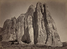
[citation needed] In 1867, photographer Timothy H. O'Sullivan, who was then known for his depictions of the destructive nature of the American Civil War, joined Clarence King's geological survey of the 40th parallel between the Rocky Mountains and the Sierra Nevada.
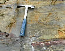
Scale is especially important in geophotography, and meter sticks, rock hammers, people, lens caps, coins, or other objects that are carried on-hand, are often placed in the frame to indicate the size of the feature being photographed.
[7] In the laboratory, photography is typically used as a cataloging tool or a means of illustrating objects on a small to microscopic scale, such as individual fossils, grains, or microstructures.
In addition to photography, on-board sensors carried by these systems perform a number of different types of analyses, ranging from visual analysis to digital elevation data gathering.
High-resolution Light Detection and Ranging (LiDAR; also known as Airborne Laser Scanning) data is used to construct digital elevation models of terrain to understand and track change and effects of rivers, glaciers, ice caps, oceans, volcanoes, and more.
[8] Data from other topography missions has yielded substantial results in the holistic and synoptic geologic understanding of the processes, such as natural hazards, at work on Earth (e.g. SRTM,[9] ASTER GDEM) and on other planets such as Mars (e.g. MOLA[10]).