Georgia State Route 20
Its counterclockwise, or western terminus is at the Alabama state line in Floyd County, and its clockwise, or eastern terminus occurs at its interchange with Lower Woolsey Road southwest of Hampton in Henry County south-southeast of the Atlanta Motor Speedway.
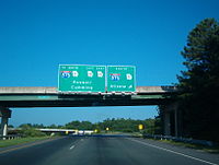
In central Forsyth County, the highway dips southeast to pass to the south of Sawnee Mountain and heads through Cumming, crossing US 19 and SR 400, and heading on into Gwinnett County, passing to the south of Lake Lanier.
The portion of SR 20 between the western end of the SR 81 concurrency and Lower Woolsey Road, the highway's clockwise/eastern terminus, was widened in the early 2000s from two lanes to four, including a new southern bypass of the city of Hampton, and more controlled access at US 19/US 41.
The primary purpose of the widening has been to facilitate the flow of traffic to and from the Atlanta Motor Speedway located near the highway's eastern terminus.
South of Lawrenceville, numbers then start to decrease once more from around 22,000 down to 14,000 around Loganville, and dip down into average of just over 8,000 in rural Walton County.
[9][10] By the end of 1926, two segments had a "sand clay or top soil" surface: from the Alabama state line to just west of Rome and from Sugar Hill to Lawrenceville.
In the northwestern part of Cartersville and farther to the west, a portion of the highway had a completed semi hard surface.
The portion of the highway at the Alabama state line had a completed semi hard surface.
[11][12] By the beginning of 1932, US 19 was shifted farther to the west and off of the current SR 20 between Buford and Lawrenceville; at the same time, US 23 was designated on this same segment.
[17][18] The next month, the western part of the segment from the Alabama state line to Rome was under construction.
[22][23] By October of that year, a small portion east of Canton had a sand clay or top soil surface.
[24][25] Later in 1936, the central portion of the SR 20/SR 61 segment, from Cartersville to Rydal, had completed grading, but was not surfaced.
The entire Forsyth County portion of the Canton–Cumming segment, except for the eastern end, was under construction.
[28][29] By the middle of the year, the central portion of SR 20/SR 61, from Cartersville to Rydal, had a completed hard surface.
Also, a small portion northeast of Buford had a sand clay or top soil surface.
[32][33] Before the year ended, about half of the total length of the segment from the Alabama state line and Rome had a completed hard surface.
With the highway being shifted southward, its former path between Rydal and Canton became part of SR 140.
[40][41] By the end of 1946, three segments were hard surfaced: Alabama state line to Rome, Cumming to Buford, and Lawrenceville to Loganville.
[45][46] By the end of 1951, the southern half of the segment from Loganville to Conyers, and a portion northeast of McDonough, had been hard surfaced.
It travels from SR 20, just east of its interchange with Interstate 75 (I-75) north of Cartersville, south to Allatoona Dam.
The highway, along with nearby Allatoona Dam road, formed the two segments of State Route 294.