Lake Superior
The Ojibwe name for the lake is gichi-gami (in syllabics: ᑭᒋᑲᒥ, pronounced gitchi-gami or kitchi-gami in different dialects),[16] meaning "great sea".
[7] There is enough water in Lake Superior to cover the entire land mass of North and South America to a depth of 30 centimetres (12 in).
The Soo Locks enable ships to bypass the rapids and to overcome the 25-foot (8 m) height difference between Lakes Superior and Huron.
Until approximately 1887, the natural hydraulic conveyance through the St. Marys River rapids determined the outflow from Lake Superior.
The low water was a continuation of the dropping lake levels from the previous year, 1925, which set low-water records for October through December.
[27] According to a study by professors at the University of Minnesota Duluth, Lake Superior may have warmed faster than its surrounding area.
[33] Lake Superior's size reduces the severity of the seasons of its humid continental climate (more typically seen in locations like Nova Scotia).
During the Precambrian (between 4.5 billion and 540 million years ago) magma forcing its way to the surface created the intrusive granites of the Canadian Shield.
It was during the Penokean orogeny, part of the process that created the Great Lakes tectonic zone, that many valuable metals were deposited.
The region surrounding the lake has proved to be rich in minerals, with copper, iron, silver, gold and nickel the most frequently mined.
The mountains steadily eroded, depositing layers of sediments that compacted and became limestone, dolomite, taconite and the shale at Kakabeka Falls.
This hard diabase protects the layers of sedimentary rock below, forming the flat-topped mesas in the Thunder Bay area.
[citation needed] In the most recent geological history, during the Wisconsin glaciation 10,000 years ago, ice covered the region at a thickness of 1.25 miles (2 km).
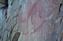
The Shield Archaic peoples arrived around 5000 BC; evidence of this culture can be found at the eastern and western ends of the Canadian shore.
They used bows and arrows, paddled dugout canoes, fished, hunted, mined copper for tools and weapons, and established trading networks.
[40] The people of the Laurel complex (c. 500 BC to AD 500) developed seine net fishing, evidence being found at rivers around Superior such as the Pic and Michipicoten.
[40] The Anishinaabe people (an ethnic grouping including the Ojibwe/Chippewa) have inhabited the Lake Superior region for over five hundred years and were preceded by the Dakota, Meskwaki (Fox), Menominee, Nipigon, Noquet and Gros Ventres.
They soon became the dominant Native American nation in the region: they forced out the Sioux and Fox and won a victory against the Iroquois west of Sault Ste.
Today, tourism is another significant industry: the sparsely populated Lake Superior country, with its rugged shorelines and wilderness, attracts vacationers and adventurers.
Exact dates for the shipping season vary each year,[44] depending on weather conditions that form and break the ice.
Wreckage of SS Cyprus—a 420-foot (130 m) ore carrier that sank on October 11, 1907, during a Lake Superior storm in 77 fathoms (460 ft or 140 m) of water—was located in August 2007.
Built in Lorain, Ohio, Cyprus was launched August 17, 1907, and was lost on her second voyage hauling iron ore from Superior, Wisconsin, to Buffalo, New York, with the sole survivor among her 23 crew being Charles G.
SS Edmund Fitzgerald is the last ship that sank in Lake Superior, 15 nautical miles (28 km; 17 mi) from Whitefish Point in a storm on November 10, 1975.
Edmund Fitzgerald was battered so intensely by Lake Superior that the 729-foot (222 m) ship split in half; her two pieces lie approximately 170 feet (52 m) apart at a depth of 88 fathoms (530 ft or 160 m).
But Lake Superior's water is cold enough year-round to inhibit bacterial growth, and bodies tend to sink and never resurface.
[48] Joe MacInnis reported that in July 1994, explorer Frederick Shannon's Expedition 94 to the wreck of Edmund Fitzgerald discovered a man's body near the port side of her pilothouse, not far from the open door, "fully clothed, wearing an orange life jacket, and lying face down in the sediment".
They are still much lower than levels considered dangerous to human health; but this steady, long-term rise is an unusual record of environmental nitrogen buildup.
It may relate to anthropogenic alternations to the regional nitrogen cycle, but researchers are still unsure of the causes of this change to the lake's ecology.
[53] As for other Great Lakes fish, populations have also been affected by the accidental or intentional introduction of foreign species such as the sea lamprey and Eurasian ruffe.