Glacier National Park (U.S.)
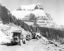
By 1932 work was completed on the Going-to-the-Sun Road, later designated a National Historic Civil Engineering Landmark, which provided motorists easier access to the heart of the park.
[14] The park region provided the Blackfeet shelter from the harsh winter winds of the plains, allowing them to supplement their traditional bison hunts with other game meat.
In 1885 George Bird Grinnell hired the noted explorer (and later well-regarded author) James Willard Schultz to guide him on a hunting expedition into what would later become the park.
[22] A few years after Grinnell first visited, Henry L. Stimson and two companions, including a Blackfoot, climbed the steep east face of Chief Mountain in 1892.
In 1910, under the influence of the Boone and Crockett Club,[25] and spearheaded by George Bird Grinnell and Louis W. Hill, president of the Great Northern, a bill was introduced into the U.S. Congress which designated the region a national park.
While the forest reserve designation confirmed the traditional usage rights of the Blackfeet, the enabling legislation of the national park does not mention the guarantees to the Native Americans.
The United States government's position was that with the special designation as a National Park the mountains ceded their multi-purpose public land status and the former rights ceased to exist as the Court of Claims confirmed it in 1935.
[29] Vacationers commonly took pack trips on horseback between the lodges or utilized the seasonal stagecoach routes to gain access to the Many Glacier areas in the northeast.
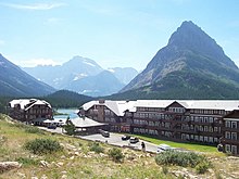
[30] The chalets, built between 1910 and 1915, included Belton, St. Mary, Going-to-the-Sun, Many Glacier, Two Medicine, Sperry, Granite Park, Cut Bank, and Gunsight Lake.
The chalets and tent camps were located roughly 10–18 miles apart, and were connected by a network of trails that allowed visitors to tour Glacier's backcountry on foot or horseback.
[34] In total, 350 buildings and structures within the park are listed on the National Register of Historic Places, including ranger stations, backcountry patrol cabins, fire lookouts, and concession facilities.
[35] In 2017, Sperry Chalet closed early for the season due to the Sprague Fire which subsequently burned the entire interior portions of the structure, leaving only the stone exterior standing.
[41] The increase in motor vehicle traffic through the park during the 1930s resulted in the construction of new concession facilities at Swiftcurrent and Rising Sun, both designed for automobile-based tourism.
[45] Some rehabilitation of major structures such as visitor centers and historic hotels, as well as improvements in wastewater treatment facilities and campgrounds, were expected to be completed by the anniversary date.
[46] The National Park Service engaged in fishery studies for Lake McDonald to assess status and develop protection programs to enhance native fish populations.
One of the tallest waterfalls is Bird Woman Falls, which drops 492 ft (150 m) from a hanging valley beneath the north slope of Mount Oberlin.
[57][58] One of the most dramatic evidences of this overthrust is visible in the form of Chief Mountain, an isolated peak on the edge of the eastern boundary of the park rising 2,500 ft (800 m) above the Great Plains.
Sedimentary rocks of similar age located in other regions have been greatly altered by mountain building and other metamorphic changes; consequently, fossils are less common and more difficult to observe.
[62] The rocks in the park preserve such features as millimeter-scale lamination, ripple marks, mud cracks, salt-crystal casts, raindrop impressions, oolites, and other sedimentary bedding characteristics.
[59] The discovery of the Appekunny Formation, a well-preserved rock stratum in the park, pushed back the established date for the origination of animal life a full billion years.
[63] Evidence of widespread glacial action is found throughout the park in the form of U-shaped valleys, cirques, arêtes, and large outflow lakes radiating like fingers from the base of the highest peaks.
[70] It is unknown how glacial retreat may affect the park's ecosystems beyond the broad concept of creating new problems over time, and intensifying or exacerbating existing challenges.
In Browning, Montana, just east of the park in the Blackfeet Reservation, a world record temperature drop of 100 °F (56 °C) in only 24 hours occurred on the night of January 23–24, 1916, when thermometers plunged from 44 to −56 °F (7 to −49 °C).
Based in West Glacier, with the main headquarters in Bozeman, Montana, the U.S. Geological Survey has performed scientific research on specific climate change studies since 1992.
No major areas of dense human population exist anywhere near the region and industrial effects are minimized due to a scarcity of factories and other potential contributors of pollutants.
Above the forested valleys and mountain slopes, alpine tundra conditions prevail, with grasses and small plants eking out an existence in a region that enjoys as little as three months without snow cover.
Between 1930 and 1970, efforts to control the spread of blister rust were unsuccessful, and continued destruction of whitebark pines appears likely, with attendant negative impacts on dependent species.
Great horned owl, Clark's nutcracker, Steller's jay, pileated woodpecker and cedar waxwing reside in the dense forests along the mountainsides, and in the higher altitudes, the ptarmigan, timberline sparrow and rosy finch are the most likely to be seen.
[123] 110 mi (177 km) of the Continental Divide National Scenic Trail spans most of the distance of the park north to south, with a few alternative routes at lower elevations if high altitude passes are closed due to snow.
Much of Glacier's backcountry is usually inaccessible to hikers until early June due to accumulated snowpack and avalanche risk, and many trails at higher altitudes remain snow-packed until July.