Lewis Overthrust
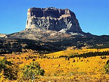
The Lewis Overthrust is a geologic thrust fault structure of the Rocky Mountains found within the bordering national parks of Glacier in Montana, United States and Waterton Lakes in Alberta, Canada.
The onset of Cordilleran orogenesis began in the Middle Jurassic time, as a result of the breakup of Pangea and North American plate motion toward subduction zones at the western margin.
[4] These terranes were accreted due to upper-crustal rocks being detached from the denser lower-crustal and proto-Pacific upper mantle lithosphere that was subducted under the North American craton.
[5] The onset of deformation of the Rocky Mountain fold and thrust belt was due to collisional tectonic forces that occurred on the west edge of the North American craton.
Strata from differing depositional environments is thought to have been scraped off of the under-riding North American craton and accreted to the over-riding Intermontane terrane during the Late Jurassic to Paleocene convergence of tectonic plates.
Studies and modern dating have found that eastward propagation of thrusting took place in four distinct pulses that are separated by relative tectonic quiescence.
[6] The Rockies were uplifted during the Laramide Orogeny which occurred between 80 and 55 million years ago during the Late Cretaceous to the Early Paleocene as a result of subduction of the Kula and Farallon plates beneath the North American continent.
This transpression in the Late Cretaceous led to the tectonic inversion of the Cordilleran miogeocline and the Belt-Purcell basin as the Lewis sheet began to buckle and fold, where strata was then overturned until a break or fault was formed.
This involved thick successions of Paleozoic rocks that make up the Corilleran miogeocline and the underlying Neoproterozoic rocks to become detached from the crystalline basement; displaced up the passive-margin ramp along which they had accumulated; and juxtaposed over the flat surface of the North American craton to form the structural culmination that defines the Main Ranges of the Canadian Rockies.
[8] Similarly, the thick succession of Mesoproterozoic strata consisting of the Belt-Purcell supergroup followed the same sequence of events leading to the structural culmination seen in the southern end of the Purcell anticlinorium.
[5] Instead, this transpression was replaced with transtension in the early Eocene involving east–west crustal extension and tectonic exhumation, which brought up mid-crustal metamorphic rocks to the surface to be exposed.
Dextral transtension on intracontinental strike-slip faults in northeastern and southwestern British Columbia culminated with the mid Eocene extensional exhumation of midcrustal metamorphic core complexes.
This leads to the basal décollement being exposed and the association with north–south faulting, dyke emplacement, and voluminous magmatism, which in turn, marked cessation of crustal shortening.
[10] Two windows in this section showing exposures of Upper Cretaceous strata exposed beneath the Lewis Thrust occur adjacent to the Flathead Fault.
Within these windows, the Lewis thrust is folded along with overlying and underlying strata in a series of northwest-trending anticlinal culminations that extend the length of the west side of the salient.
U-Pb dating of zircons from various deformed and crosscutting mid-crustal granitic rocks in south-central British Columbia provided cooling ages of 59 Ma.
[5] 75 km East along the profile is the exposure of the Lewis fault in the Waterton area, which directly links to the most displaced portion of the hanging wall.
[9] Measuring the distance between the footwall cutoff and the fault exposure at the Earth's surface, total movement of the Lewis thrust sheet was determined.
Moreover, samples from the hanging wall collected in close proximity to the fault plane show no evidence for heating during progressive burial of sediments.