Mount Adams (Washington)
Some of its glacial ice feeds the Avalanche Glacier below it to the southwest while the rest tumbles over some large cliffs to its diminutive lower section to the west.
[32] Potato Hill is a cinder cone on Adams' north side that was created in the late Pleistocene and stands 800 feet (240 m) above its lava plain.
Unlike Adams, the Goat Rocks volcano was periodically explosive and deposited ash 2.5 million years ago that later solidified into 2,100-foot (640 m) thick tuff layers.
[42] Adams is made of several overlapping cones that together form an 18-mile-diameter (29 km) base which is elongated in its north–south axis and covers an area of 250 square miles (650 km2).
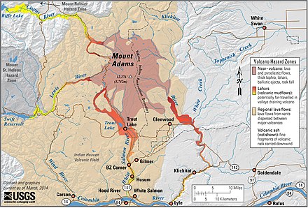
[7] Andesite and basalt flows formed a 20-to-200-foot (6 to 60 m) thick circle around the base of Mount Adams, and filled existing depressions and ponded in valleys.
Since its construction, constant emissions of heat and caustic gases have transformed much of the rock into clays (mostly kaolinite), iron oxides, sulfur-rich compounds and quartz.
[45] Since then, thermal anomalies (hot spots) and gas emissions (including hydrogen sulfide) have occurred especially on the summit plateau and indicate that Adams is dormant, not extinct.
However, since the interior of the main cone is little more than a pile of fragmented lava and hydrothermally altered rock, there is a potential for very large landslides and other debris flows.
Its principal feature is an 18-mile (29 km) long linear zone of shield volcanoes, cinder cones, and flows with volumes of up to 23 cubic miles (96 km3) with the highest peak, Lemei Rock.
[48][49][50] Like many other Cascade volcanoes, Mount Adams offers many recreational activities, including mountain climbing, backcountry skiing, hiking and backpacking, berry picking, camping, boating, fishing, rafting, photography, wildlife viewing, and scenic driving among other things.
[19][54] On the south side of Adams, the Morrison Creek area provides additional opportunities for hiking, backpacking, biking, and equestrian sports with several long loop trails.
The Mount Adams Recreation Highway (FR 80) is plowed all the way to Pineside and Snow King Sno-parks at about 3,000 feet (910 m) elevation for most of the year, as long as there is enough money in the Forest Service's winter budget.
Speelyi then managed to overpower Enumtla and decreed that the thunderbird could no longer terrify the people, could only thunder on hot days, and could not destroy with lightning.
[13] However, it was not official until 1853, when the Pacific Railroad Surveys, under the direction of Washington Territory governor Isaac I. Stevens, determined its location, described the surrounding countryside, and placed the name on the map.
The topographer for the Pacific Railroad Surveys, Lt. Johnson K. Duncan, and George Gibbs, ethnologist and naturalist for the expedition, thought it was about the same height as St. Helens.
Their route took them up the Rusk Glacier, onto Battlement Ridge, up and over The Castle, and across the vast, heavily crevassed eastern side of the summit ice cap.
[97] Adams is home to the oldest building on the Gifford Pinchot National Forest, the Gotchen Creek Guard Station just south of the A. G. Aiken Lava Bed.
[103][104] The four men assigned the job, Arthur "Art" Jones, Adolph Schmid, Julius Wang, and Jessie Robbins, had a difficult task ahead of them until they engineered a way to quickly and, for the most part, safely bring the building materials up the slope using a deadman/rope technique.
[104] Construction of the standard D-6 building with a ¼ second story cupola[105] began in the summer of 1920 and was completed a year later by Art, Adolph, James Huffman and Joe Guler.
The initial test pits were dug by hand, but this proved to be dangerous work and an alternative was needed to drill through the up to 210 feet (64 m) thick ice cap more safely.
In the years following, Dean periodically attempted to restart this venture and in 1946, he and Lt. John Hodgkins made several landings by airplane on the summit ice cap.
The snowpack at Potato Hill starts building in late October to early November and the last of the snow generally melts by the beginning of June, but occasionally lingers into July.
[113] Temperatures and precipitation can be highly variable around Adams, due in part to its geographic location astride the Cascade Crest, which gives it more of a continental influence than some of its neighbors.
Adams is also home to many hardwoods as well including the tree species big leaf maple, Oregon white oak, quaking aspen, black cottonwood, and red alder.
The notable Bird Creek Meadows includes in its famous display, magenta paintbrush, arrowleaf ragwort, penstemons, lupines, monkeyflowers, mountain heathers, and many others.
In wetlands, generally at lower elevations, one can find bog blueberry, highbush cranberry, sundew, purple cinquefoil, and flatleaf bladderwort, in addition to many sedges and rushes.
Hoary marmots and pikas make their home on open rocky areas at any altitude while the elusive snowshoe hare lives throughout the forest.
[116][123][126][127] The profusion of wildflowers attracts a large number of pollinators including butterflies such as Apollos, Melitaea, Coenonympha, snowflakes, painted ladies, garden whites, swallowtails, skippers, admirals, sulphurs, blues, and fritillaries.
Raptors that live in the forest and meadows include Accipiters, red-tailed hawks, golden and bald eagles, ospreys, great horned owls, and falcons.
Protected wildlife includes deer, elk, beaver, coyote, otter, small rodents, bald eagle, greater sandhill crane, and the Oregon spotted frog.