Glacier mass balance
Since higher elevations are cooler than lower ones, the disappearance of the lowest portion of the glacier reduces overall ablation, thereby increasing mass balance and potentially reestablishing equilibrium.
However, if the mass balance of a significant portion of the accumulation zone of the glacier is negative, it is in disequilibrium with the local climate.
In the case of positive mass balance, the glacier will continue to advance expanding its low elevation area, resulting in more melting.
[13] To determine mass balance in the accumulation zone, snowpack depth is measured using probing, snowpits or crevasse stratigraphy.
In temperate glaciers, the insertion resistance of a probe increases abruptly when its tip reaches ice that was formed the previous year.
The mass balance is measured on the fixed date each year, again sometime near the start of October in the mid northern latitudes.
Sometimes the earliest data for the glacier surface profiles is from images that are used to make topographical maps and digital elevation models.
Aerial mapping or photogrammetry is now used to cover larger glaciers and icecaps such found in Antarctica and Greenland, however, because of the problems of establishing accurate ground control points in mountainous terrain, and correlating features in snow and where shading is common, elevation errors are typically not less than 10 m (32 ft).
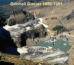
[18] The similarity of response of glaciers in western North America indicates the large scale nature of the driving climate change.
Taku is the world's thickest known temperate alpine glacier, and experienced positive mass balance between the years 1946 and 1988, resulting in a huge advance.
[20] The Juneau Icefield Research Program also has studied the mass balance of the Lemon Creek Glacier since 1953.
In terms of the cumulative specific balances, Hintereisferner experienced a net loss of mass between 1952 and 1964, followed by a period of recovery to 1968.
Tasman Glacier has been studied since then by the New Zealand Geological Survey and later by the Ministry of Works, measuring the ice stratigraphy and overall movement.
[26] Norway maintains the most extensive mass balance program in the world and is largely funded by the hydropower industry.
It was here that the first mass balance program was initiated immediately after World War II, and continues to the present day.
This survey was the initiation of the mass balance record of Storglaciären Glacier, and constitutes the longest continuous study of this type in the world.
Storglaciären has had a cumulative negative mass balance from 1946 to 2006 of −17 m. The program began monitoring the Rabots Glaciär in 1982, Riukojietna in 1985, and Mårmaglaciären in 1988.
[28] Glacier mass balance is measured once or twice annually on numerous stakes on the several ice caps in Iceland by the National Energy Authority.
Regular pit and stake mass-balance measurements have been carried out on the northern side of Hofsjökull since 1988 and likewise on the Þrándarjökull since 1991.
Profiles of mass balance (pit and stake) have been established on the eastern and south-western side of Hofsjökull since 1989.
As a consequence, variations in the mass of glaciers reflect changes in climate and the energy fluxes at the Earth's surface.
Traditional field methods are combined with remote sensing techniques to track changes in mass, geometry and the flow behaviour of the two glaciers.
[31] The GSC operates Canada's Glacier-Climate Observing System as part of its Climate Change Geoscience Program.
Sites in the Cordillera include the Helm, Place, Andrei, Kaskakwulsh, Haig, Peyto, Ram River, Castle Creek, Kwadacha and Bologna Creek Glaciers; in the Arctic Archipelago include the White, Baby and Grise Glaciers and the Devon, Meighen, Melville and Agassiz Ice Caps.
GSC reference sites are monitored using the standard stake based glaciological method (stratigraphic) and periodic geodetic assessments using airborne lidar.
The PTAA (precipitation-temperature-area-altitude) model requires only daily observations of precipitation and temperature collected at usually low-altitude weather stations, and the area-altitude distribution of the glacier.
The fifteen independent coefficients that are used to convert observed temperature and precipitation to ablation and snow accumulation apply a simplex optimizing procedure.
The simplex automatically and simultaneously calculates values for each coefficient using Monte Carlo principals that rely on random sampling to obtain numerical results.
Application of the model to Bering Glacier in Alaska demonstrated a close agreement with ice volume loss for the 1972–2003 period measured with the geodetic method.
[36] Correlation between ablation of glaciers in the Wrangell Range in Alaska and global temperatures observed at 7000 weather stations in the Northern Hemisphere indicates that glaciers are more sensitive to the global climate than are individual temperature stations, which do not show similar correlations.