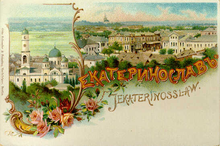
Yekaterinoslav Governorate
Covering an area of 63,392 km2 (24,476 sq mi), and being composed of a inhabitant of 2,113,674 by the census of 1897,[1] it bordered Poltava Governorate to the north, Don Host Oblast to the east, Sea of Azov to the southeast, Taurida Governorate to the south, and Kherson Governorate to the east, and covered the area of the Luhansk, Donetsk, Dnipropetrovsk, and Zaporizhzhia Oblasts of modern Ukraine.
The governorate was created in place of Novorossiysk Governorate in 1802 and encompassed a huge area of the southern Ukraine.
From the second half of the 19th century, with the founding of Yuzovka (Donetsk), the governorate became the coal-mining and metallurgical center of the then Ukraine, incorporating the Dnieper Industrial Region and the Donbass (Donets Basin).
The nationalities within the governorate were Ukrainians – 68.9%, Russians – 17.3%, Jews (4.7%), Germans (3.8%), Greeks (2.3%), and Tatars (0.8%).
From the turn of the 19th century until 1887 city of Rostov-na-Donu and all the Taganrog uyezd were part of the governorate, but before the census of 1897 took place they were transferred to the Don oblast.