Grand Bay (New Brunswick)
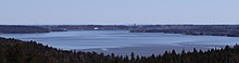
The Grand Bay is a body of water at the confluence of the Wolastoq and Kennebecasis rivers in southern New Brunswick, Canada.
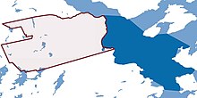
The bay is approximately 19.7 km2 and spans across the boundary between Saint John and Kings counties.
[1] The Grand Bay's northern terminus is generally accepted to be Brandy Point on the western bank of the Wolastoq and Lands End on the Kingston Peninsula.
To the south, the Grand Bay extends to Boars Head in Saint John's west side where the river splits into the South Bay and the Pokiok Narrows.
It is often claimed that the Grand Bay was named by Samuel de Champlain in 1604,[3][4][5] but this story is likely apocryphal.