Grande Ronde River
The river was used for centuries by multiple Native American tribes, who fished, gathered and hunted across much of the watershed and convened in the Grande Ronde Valley for trade.
European exploration began with the fur trade in the early 1800s; later, the Grande Ronde Valley provided a key resting point along the Oregon Trail.
Nearby gold discoveries drove emerging farming and logging industries in the Grande Ronde region, and by the 1880s most indigenous peoples had been forced away from the area and onto reservations, though several tribes maintain subsistence fishing rights along the river.
While the Grande Ronde and Wallowa Valleys developed into productive farming areas, further efforts to regulate and dam the river in the 20th century proved unsuccessful.
[6] The river initially flows north through the Wallowa-Whitman National Forest, turning east where Meadow Creek joins it from the left near Camp Elkanah.
It receives Menatchee and Cottonwood Creeks from the left, then is crossed by State Route 129 on the Grande Ronde River Bridge at Boggan's Oasis southwest of Anatone.
[3] The Grande Ronde River basin is founded on multiple terranes, or crustal fragments, that accreted onto the North American continent during the Mesozoic 248–65 million years ago (Ma).
About 160–100 Ma, multiple igneous plutons intruded into the crust beneath this area, the largest of which would eventually form the Wallowa Mountains as the region experienced tectonic uplift that raised the land above sea level.
[26] The outline of the Grande Ronde watershed began to take shape about 14 Ma, as tectonic uplift combined with the effects of basalt eruptions blocked westward drainage from the region to form a large geologic depression, the "Troy basin".
[27] The higher elevations in the Blue Mountains to the west were used by the Nez Perce and multiple Columbia Plateau tribes, who traveled to these areas in summer to hunt, fish and gather roots and berries.
[41]: 176 The Nez Perce had several villages on the Grande Ronde below the Wenaha, including Híinezpu at the mouth of Bear Creek, and Qemúynem at the confluence with the Snake River.
[41]: 184–185 A Nez Perce legend tells that the course of the lower Grande Ronde was created by Beaver, after he stole fire from the pine trees in the Blue Mountains to bring to the other animals so they could warm themselves.
[45]: 35 [46]: 192 French-Canadian fur trappers who subsequently visited the area dubbed it Grande Ronde, meaning "great circle", a name which was recorded by Peter Skene Ogden in 1827.
[47]: 147 U.S. Army officer Benjamin Bonneville explored the lower Grande Ronde River on an 1834 expedition, after also failing to find a way down the Snake through Hells Canyon.
Some Nez Perce leaders were pressured into signing a second treaty that greatly shrank the size of their reservation, eliminating all the lands in Washington and Oregon, and thus the Grande Ronde watershed, from their use.
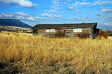
The community of Hilgard developed on the old Oregon Trail about 5 miles (8.0 km) west of La Grande, as a supply point for miners, ranchers and loggers.
The Wallowa Union Railroad Authority now operates the line; since 2004 it has hosted a heritage rail service, the Eagle Cap Excursion Train,[66] between Elgin and Joseph.
[84] Funded primarily by the Bonneville Power Administration, it has coordinated hundreds of projects in the Grande Ronde River basin to conserve instream flows, remove fish passage barriers, mitigate erosion and restore riparian habitats.
However, chinook salmon and steelhead returns have not increased substantially in the 1992–2023 period,[81] due to the effects of the Snake and Columbia River dams on fish migration.
Most of the original grasslands have been replaced by agriculture or heavily altered by livestock grazing, which has caused erosion and introduced invasive plants such as cheatgrass.
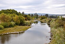
The perennial Tule Lake was located in the southern part of the valley, where the Grande Ronde and Catherine Creek converged to form the most significant area of wetlands.
[10]: 24 Beaver were widespread, and their ponds were a major factor in forming wetlands, creating a diversity of water depths and vegetation communities that provided shade and food sources for salmon and other fish.
[10]: 24 Robert Stuart, a member of Hunt's 1811 expedition, described the wetlands as such: "This plot is at least six miles in circumference, in but few places swampy, of an excellent soil, and almost a dead level; with the Glaize [Grande Ronde] and its two branches meandering in every direction through it – the banks of these streams are high and muddy, covered in particular places with dwarf Cottonwoods, and the residue in a large growth of Willows, which afford an inexhaustible stock of food for the incredible multitudes of Furr'd race who reside in their bosoms, but the S. East fork [Catherine Creek] excels both the others, particularly in the number of its inhabitants of the Otter tribe – a few Deer and Racoon are the only animals you may add to the Elk, Beaver and otter as being natives of this tract.
The State Ditch diverted the Grande Ronde River away from this flood-prone lowland area, leaving Catherine and Ladd Creeks as the only surface water inflows.
There are eighteen small reservoirs in the upper Grande Ronde basin upstream of the Wallowa River, most of which store water for irrigation or recreation purposes.
A dam regulates the level of Wallowa Lake to store up to 42,750 acre-feet (52,730,000 m3); this is the largest surface water storage facility in the Grande Ronde River system.
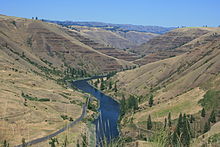
The Wild and Scenic section of the Grande Ronde extends for 43.8 miles (70.5 km) from Rondowa, at the confluence of the Wallowa River, to the Oregon–Washington state line.
[101] The entire 21.6-mile (34.8 km) main stem of the Wenaha River is protected, with the section in the Umatilla National Forest designated "Wild", and from there to Troy as "Scenic" and "Recreational".
[111]: 51 Bird hunting locations near the river include the Wenaha Wildlife Area around Troy, and parts of Ladd Marsh in the Grande Ronde Valley.
[114] The Narrows, located about 5 miles (8.0 km) from the confluence with the Snake, is the only Class IV rapid on the Grande Ronde and is considered quite dangerous, especially at low water during which the river constricts into a small bedrock chute.