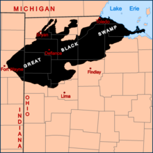
Great Black Swamp
The boundary was determined primarily by ancient sandy beach ridges formed on the shores of Lakes Maumee and Whittlesey, after glacial retreat several thousand years ago.
[7] Near its southern edge at the southwestern corner of present-day Auglaize County, wheeled transportation was impossible during most of the year, and local residents thought the rigors of travel to be unsuitable for anyone except adult men.
In the lowest, flattest areas, prone to permanent inundation, deciduous swamp forests predominated, characterized especially by species of ash, elm, cottonwood and sycamore.
In slightly higher areas with some topographic relief and better drainage, beech, maples, basswood, tuliptree and other more mesic species were dominant.
Although much of the area to the east, south, and north was settled in the early 19th century, the dense habitat and difficulty of travel through the swamp delayed its development by several decades.
Bowling Green, Ohio resident James B. Hill expedited the draining of swampy areas with his Buckeye Traction Ditcher.
[citation needed] The story of the first European settlement in 1833 in the Great Black Swamp at Lauber Hill is told in "Out of the Wilderness, History of the Central Mennonite Church," 1835-1960.

The ridge was formed at the southern shore of the ancient lake. In the distance, a completely flat expanse of agricultural land extends to the horizon. In the foreground a ditch used to drain the swamp is visible. [ 1 ] [ 2 ]