Greater Nepal
[2] These claims typically include the areas controlled by Nepal between 1791 and 1816, a period that ended with the Anglo-Nepalese War and the signing of Sugauli Treaty.
[7][8] In the 18th century, the king of the Gorkha Kingdom, Prithvi Narayan Shah, started a process of expansion, conquering Kathmandu in 1768 and making it his new capital.
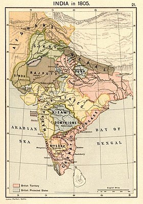
[11] After the death of Prithvi Narayan Shah, the Gorkha state continued to expand, conquering the Gandaki and Karnali basins, and then Kumaon and Garhwal (1792), halting at the Sutlej River where the Sikh Empire exerted its influence (1809–10).
[18] Negotiations for a general settlement took place at Sugauli in Bihar and agreed in December 1815, but ratified only after Ochterlony advanced to Makwanpur, thirty miles short of Kathmandu.
[18] Among the terms of the Treaty of Sugauli was also the Nepalese withdrawal from the territory of Sikkim east of the Mechi river, which was a British ally in the war.
"[29] Shreshta narrates that, before the Sugauli Treaty, Nepal extended up to the confluence of Gandak and Ganges Rivers in the south, and to Shigatse and Tashilhunpo in the north.
[citation needed] However, upon forming a coalition government after the 2008 Nepalese Constituent Assembly election, the leader of the Communist Party of Nepal (Maoist) and then-prime minister Pushpa Kamal Dahal (popularly known as "Prachanda") stated that the 1950 Indo-Nepal Treaty of Peace and Friendship would be "scrapped".
Late Nepali Prime Minister Girija Prasad Koirala called the idea of Greater Nepal "a product of unstable minds".
"[34] In 2023 when the Mauryan Empire mural in India's new Parliament building appeared in the newspapers, some politicians of the ruling Bharatiya Janata Party started branding it an Akhand Bharat map.