Greeleyville, South Carolina
Greeleyville's seal and flag feature a depiction of the first Town Hall, which was built in the 1890s, as well as two arms, one black and one white, holding a tobacco leaf and a cotton boll.
[5] These symbols represent the unity and cooperation among all the people of Greeleyville and pay tribute to the town's agricultural heritage.
[12] The settlement of Greeleyville traces back to the late nineteenth century, when Samuel J. Taylor, a veteran of the American Civil War, came to the present site of the town with his partner, S.J.
[13] Taylor used his expertise in the mercantile industry to bring prosperity to the area and although his timber holdings became exhausted within the first fifteen years, opted to remain in the emerging town for both financial and sentimental reasons.
[13][14] Greeleyville obtained its name when Taylor, who was depending on the turpentine industry, had ordered a bill of goods for his store and was in need of an address.
[14] Boyle's efforts in local manufacturing, merchandising, and other fields significantly contributed to the growth and prosperity of Greeleyville.
[16] By the mid twentieth century, most sources of employment once available to residents of Greeleyville were no longer existent and this led many to begin seeking work in other communities throughout the state.
[15] The town's only chain grocery store, IGA, moved to a larger location with expanded parking in 1984.
[19] The structure is named for senator Ronnie A. Sabb and the late Leonard Jonte, the former CEO and president of the Bank of Greeleyville, who died in 2008.
[22] President Bill Clinton traveled to Greeleyville in June 1996 to attend the dedication of the rebuilt church, vowing to enlist the full power of the federal government to put an end to the mass burnings of African American churches prevalent at the time.
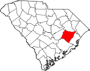
[24] Locations listed on the National Register of Historic Places: According to the United States Census Bureau, the town has a total area of 1.2 square miles (3.1 km2), all of it land.