Osser
Both summits lie on the German side in the county of Cham and on the municipal boundary between Lohberg to the southeast and Lam to the northwest.
The pointed shape of the summit on the German side of the border means that the last 50 vertical metres or so involve an easy climb.
Because the Osser is one of the best viewing mountains in the whole of the Bavarian Forest, it receives large numbers of German and Czech visitors on summer weekends, both hikers and tourists.
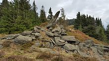
The rocky crags and numerous blocks are the result of increased weathering and erosion under the periglacial climatic conditions of recent geological history.
[5] The crags of the Großer Osser consist of quartz-rich, strongly folded mica slates, which contain numerous garnets (up to 4 mm diameter) in places.
[7] The planned Johanneszeche pumped storage hydropower station, rejected by the townsfolk of Lam, was to have located its upper basin on the Osser and an almost four kilometre long section of the pressure pipe was to be laid along an existing path.