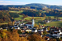
Bavarian Forest
The linguistic usage of the German-Bavarian authorities, the impact of tourism, and the presence formerly of the Iron Curtain contributed to the fact that the term "Bavarian Forest" was increasingly extended to mean the entire low mountain region on the German side of the border between Bavaria and Bohemia.
As a result of political developments after 1989, most recently the accession of the Czech Republic to the Schengen area, however, there is a discernible trend to see the low mountain range on the German-Czech border as a unit, especially in terms of tourism.
Furthermore, the Bavarian Forest is known for its glassblowing in the area of Zwiesel and is also known in the field of geoscience as a result of the fundamental station of Wettzell at Bad Kötzting.
However, the highest peaks of the low mountain range are found on a second ridgeline, southwest of the main ridge, and which also runs from northwest to southeast.
The Zeller Valley (Zellertal), which stretches from Bad Kötzting via Bodenmais and northeast of Langdorf to Bettmannsäge and continues in relief terms as far as Spiegelau, separates a third, slightly lower ridgeline, which bounds the High Bavarian Forest to the southwest.
Beginning at the Zeller Höhe (850 m), the northernmost mountain of the Anterior Bavarian Forest overall, this range climbs to 1,092 m) at the Hirschenstein.
On the northern extension of this ridge in the Regen valley lies the Hornbergwald forest, which reaches 844 m at the Abendberg and thus clearly towers above the floor of the basin.
South of it and separated by the state road, St 2135, is a chain of summits, the Hausstein Mountains (Haussteinberge) and Leopoldswald, running eastwards.
To the south of the Brotjacklriegel, the isolated Stierberg (716 m), southwest of Zenting, bounds the Lallinger Winkel (see below) markedly in the east.
Even higher but clearly less prominent are an unnamed hill northwest of Zinzenzell at 720 m and a hill southeast of Wiesenfelden that reaches 740 m. In the south near the Danube, in the Waxenberger Forst, the Kobelberg reaches a height of 703 m. Between Roding and Wiesent, the Falkensteiner Vorwald is divided centrally by a slight depression which follows the south-southwesterly course of the Regen near Roding.
The main summit in this high-relief part of the landscape, is the Jugendberg (611 m) immediately southwest of Nittenau, but more spectacular are the slopes of the 664 m high Gailenberg above the bend in the Regen.
In the east, roughly from Waldkirchen, the Abbey Country transitions into the Wegscheid Plateau, which flows seamlessly into the Mühlviertel region of Lower Austria.
The Bavarian Forest is the rump of a Palaeozoic mountain chain, whose bedrock is classified as Late Proterozoic to Silurian.
After several phases of deformation and metamorphosis the mostly sedimentary, but also plutonic and volcanic, source rocks were metamorphosed over millions of years into the present-day gneisses.
Originally created as a large-scale fault during the UpperDevonian to Upper Carboniferous, it was reactivated by fracture tectonics in the outgoing Palaeozoic and early Mesozoic to form a herringbone crack system (Fiederspaltensystem), which was filled with quartz by the penetration of hydrothermal solutions.
Due to the strength of the rock, this quartz wall protrudes up to 30 metres above the surrounding area for long distances.
Between Regensburg and Passau, there is a marked difference in height between the forested mountains to the northeast and the Danube plain ("Gäuboden") to the southwest.
This dividing line between the Tertiary Hill Country and the Bavarian Forest is marked by the Danube Edge Fault (Donaurandbruch), a geological disruption between the sunken crystalline basement, lying beneath the Tertiary and Quaternary deposits of the molasse basin, and the still visible part northwest of this line, which belongs to the Bavarian Forest.
Due to the uplift of the Bavarian Forest, which also affected the Neuburg Forest and the Sauwald, there was an antecedent incision of the rivers Inn and Danube into this area of the crystalline basement which led to the formation of a narrow valley zone from Pleinting down the Danube into Austria and south of Passau, where the Inn has formed a deeply incised riverbed.