Area 51
Area 51 is the common name of a highly classified United States Air Force (USAF) facility within the Nevada Test and Training Range.
A remote detachment administered by Edwards Air Force Base, the facility is officially called Homey Airport (ICAO: KXTA, FAA LID: XTA)[2] or Groom Lake (after the salt flat next to its airfield).
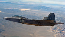
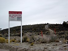
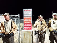
Details of its operations are not made public, but the USAF says that it is an open training range,[3] and it is commonly thought to support the development and testing of experimental aircraft and weapons systems.
[5] The intense secrecy surrounding the base has made it the frequent subject of conspiracy theories and a central component of unidentified flying object (UFO) folklore.
[8] The CIA publicly acknowledged the base's existence on 25 June 2013, following a Freedom of Information Act (FOIA) request filed in 2005, and declassified documents detailing its history and purpose.
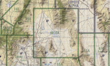
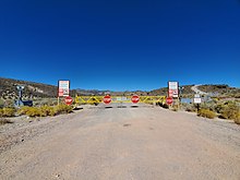
After leaving the restricted area, Groom Lake Road descends eastward to the floor of the Tikaboo Valley, passing the dirt-road entrances to several small ranches, before converging with State Route 375, the "Extraterrestrial Highway", south of Rachel.
[14] Groom Lake is a salt flat[15] in Nevada used for runways of the Nellis Bombing Range Test Site airport (XTA/KXTA) on the north of the Area 51 USAF military installation.
[27] The airfield on the Groom Lake site began service in 1942 as Indian Springs Air Force Auxiliary Field[28] and consisted of two unpaved 5,000-foot (1,524 m) runways.
[29] The Central Intelligence Agency (CIA) established the Groom Lake test facility in April 1955 for Project AQUATONE: the development of the Lockheed U-2 strategic reconnaissance aircraft.
It was a perfect natural landing field [...] as smooth as a billiard table without anything being done to it.The lake bed made an ideal strip for testing aircraft, and the Emigrant Valley's mountain ranges and the NTS perimeter protected the site from visitors; it was about 100 mi (160 km) north of Las Vegas.
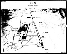
[9]: 57 On 4 May 1955, a survey team arrived at Groom Lake and laid out a 5,000-foot (1,500 m) north–south runway on the southwest corner of the lakebed and designated a site for a base support facility.
[32] This included testing at Groom Lake, which had inadequate facilities consisting of buildings for only 150 people, a 5,000 ft (1,500 m) asphalt runway, and limited fuel, hangar, and shop space.
They marked an Archimedean spiral on the dry lake approximately two miles (three kilometers) across so that an A-12 pilot approaching the end of the overrun could abort instead of plunging into the sagebrush.
Facilities in the main cantonment area included workshops and buildings for storage and administration, a commissary, a control tower, a fire station, and housing.
[35] The CIA facility received eight USAF F-101 Voodoos for training, two T-33 Shooting Star trainers for proficiency flying, a C-130 Hercules for cargo transport, a U-3A for administrative purposes, a helicopter for search and rescue, and a Cessna 180 for liaison use, and Lockheed provided an F-104 Starfighter for use as a chase plane.
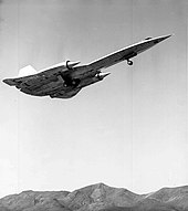
"With the D-21's systems activated and running, and the launch aircraft at the correct point, the M-21 would begin a slight pushover, the LCO would push a final button, and the D-21 would come off the pylon".
An accident on 30 July 1966 with a fully fueled D-21, on a planned checkout flight, suffered from an unstart of the drone after its separation, causing it to collide with the M-21 launch aircraft.
[30]: 132 Davis-Monthan is an open base, with public tours of the storage area at the time, so the odd-looking drones were soon spotted and photos began appearing in magazines.
[citation needed] Munir Redfa's defection with a Mikoyan-Gurevich MiG-21 from Iraq for Israel's Mossad in Operation Diamond led to the HAVE DOUGHNUT, HAVE DRILL and HAVE FERRY programs.
A complex of actual and replica Soviet-type threat systems began to grow around "Slater Lake", a mile northwest of the main base, along with an acquired Soviet "Barlock" search radar placed at Tonopah Air Force Station.
[47] Area 51 is a common destination for Janet, a small fleet of passenger aircraft operated on behalf of the Air Force to transport military personnel, primarily from Harry Reid International Airport.
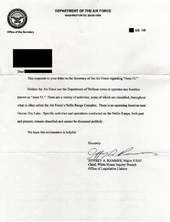
[50] On 25 June 2013, the CIA released an official history of the U-2 and OXCART projects which acknowledged that the U-2 was tested at Area 51, in response to a Freedom of Information Act request submitted in 2005 by Jeffrey T. Richelson of George Washington University's National Security Archive.
[55] Congressman Lee H. Hamilton, former chairman of the House Intelligence Committee, told 60 Minutes reporter Lesley Stahl, "The Air Force is classifying all information about Area 51 in order to protect themselves from a lawsuit.
[57] Judge Pro rejected the government's argument, so President Bill Clinton issued a Presidential Determination exempting what it called "the Air Force's Operating Location Near Groom Lake, Nevada" from environmental disclosure laws.
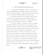
But he inclined leave decision to me (DCI)—I confessed some question over need to protect since: The declassified documents do not disclose the outcome of discussions regarding the Skylab imagery.
[8] Theories include: Many of the hypotheses concern underground facilities at Groom or at Papoose Lake (also known as "S-4 location"), 8.5 miles (13.7 km) south, and include claims of a transcontinental underground railroad system, a disappearing airstrip nicknamed the "Cheshire Airstrip", after Lewis Carroll's Cheshire cat, which briefly appears when water is sprayed onto its camouflaged asphalt, and engineering based on alien technology.
Sightings occurred most often during early evening hours, when airline pilots flying west saw the U-2's silver wings reflect the setting sun, giving the aircraft a "fiery" appearance.
The project checked U-2 and later OXCART flight records to eliminate the majority of UFO reports that it received during the late 1950s and 1960s, although it could not reveal to the letter writers the truth behind what they saw.
Burisch's scholarly credentials are the subject of much debate, as he was apparently working as a Las Vegas parole officer in 1989 while also earning a PhD at State University of New York (SUNY).
[3] Two music festivals in rural Nevada, AlienStock and Storm Area 51 Basecamp, were subsequently organized to capitalize on the popularity of the original Facebook event.