Groundwater model
An unambiguous definition of "groundwater model" is difficult to give, but there are many common characteristics.
Such groundwater models try to predict the fate and movement of the chemical in natural, urban or hypothetical scenario.
[1] The mathematical or the numerical models are usually based on the real physics the groundwater flow follows.
These mathematical equations are solved using numerical codes such as MODFLOW, ParFlow, HydroGeoSphere, OpenGeoSys etc.
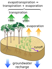
Flows through the unsaturated zone that couple surface water to soil moisture and groundwater can be upward or downward, depending upon the gradient of hydraulic head in the soil, can be modeled using the numerical solution of Richards' equation[2] partial differential equation, or the ordinary differential equation Finite Water-Content method [3] as validated for modeling groundwater and vadose zone interactions.
Many groundwater models are made for the purpose of assessing the effects hydraulic engineering measures.
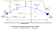
The parameters usually concern the geometry of and distances in the domain to be modelled and those physical properties of the aquifer that are more or less constant with time but that may be variable in space.
Important parameters are the topography, thicknesses of soil / rock layers and their horizontal/vertical hydraulic conductivity (permeability for water), aquifer transmissivity and resistance, aquifer porosity and storage coefficient, as well as the capillarity of the unsaturated zone.
The applicability of a groundwater model to a real situation depends on the accuracy of the input data and the parameters.
As many parameters are quite variable in space, expert judgment is needed to arrive at representative values.
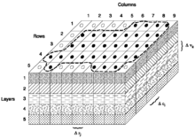
Two and three-dimensional models can take into account the anisotropy of the aquifer with respect to the hydraulic conductivity, i.e. this property may vary in different directions.