Guiengola
[4] The site also has fortified walls, houses, ballgame fields, other tombs and a very large "palace" with remains of artificial ponds and terraces.
Archaeological evidence from the period, such as burned temples and sacrificed captives, suggest that the 3 societies were in some sort of competition.
The area's environment is well suited for agriculture, especially the cultivation of maize, making it a desirable place for settlers.
[5] Archaeological research has provided clear evidence that Guiengola was a permanent settlement with much more complexity than is given in the ethnohistorical descriptions.
Colonial documents only describe Guiengola as a fortress, but previous archaeological projects have revealed public, ceremonial, and residential areas.
[8] These projects made valuable contributions to our understanding of the site, especially with the documentation of a ceremonial precinct composed of the two largest temples in the settlement; however, without access to modern remote-sensing tools, previous projects were unable to capture the full extension of the site.
[9] Guiengola is located in a hard-to-access plateau covered by subtropical dry broadleaf forest, making it logistically challenging to survey.
Investigations by Ramón Celis with airborne lidar scan and archaeological surveys between 2018 and 2023 showed that this settlement was a fortified city of 360 hectares and more than 1000 structures including a walled system of fortifications, an internal road network, and a hierarchically organized city.
[12] The name Zapotec is an exonym coming from Nahuatl tzapotēcah (singular tzapotēcatl), which means "inhabitants of the place of sapote".
They left archaeological evidence at the ancient city of Monte Albán in the form of buildings, ball courts, magnificent tombs and grave goods including finely worked gold jewelry.
Other important pre-Columbian Zapotec sites include Lambityeco, Dainzu, Mitla, Yagul, San José Mogote, El Palmillo and Zaachila.
[16] The Zapotecs developed a calendar and a logosyllabic system of writing that used a separate glyph to represent each of the syllables of the language.
Apparently the mexicas from Tenochtitlan were seeking tributes and also, control and free access to the Soconusco[19] and Guatemala trade routes.
Cocijoeza and his allies, the Mixteco civilization, resisted the attacks under the Ahuizotl (1486-1502)[20] Aztec Tlatoani leadership.
[2] From its location, shape and construction system, it is believed Guiengola was a fortified site where Zapotecs guarded and defended against attacks from hostile groups.
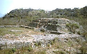
[23] Guiengola is formed by a ceremonial center on a flat 150 x 200 m surface artificially constructed between two rocky hills.
[12] All the structures were built with small stone slabs from the area, jointed with mortar and finished with stucco.
The Eastern pyramid consists of three bodies and in the west side it has an 8 meters stairway that leads to the top; the staircase is embedded in the building.
The pyramids probable were temples where priests held rites and ceremonies to their deities; The altars were places for offering placement and the plazas where people assembled.
It contains a round shape lookout built on a natural rock from where a large isthmus territory can be seen.
It consisted of 64 rooms and other structures built on an 11,000 m2 area, heavily guarded by the rocky terrain and arranged irregularly.
The Ball Game Court is located to the east of the Main Plaza, to its left side are other structures, highlighting two with circular form, of which some investigators have suggested were astronomical observatories.
A few mounds or promontories qualify as observatories; from there it is possible to observe any movement in the river basin and has a nearly complete vision of the ceremonial area.