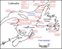
Gulf of St. Lawrence
The Gulf of St. Lawrence fringes the shores of the provinces of Quebec, New Brunswick, Nova Scotia, Prince Edward Island, Newfoundland and Labrador, in Canada, plus the islands Saint-Pierre and Miquelon, possessions of France, in North America.
[5][6][7] The secrets of the Saint-Laurent,[8] marine weather guide 2013, of 100 pages, provides information on a multitude of facets of the great river in all seasons.
The machine starts up in December with the formation of ice cubes between Montreal and Quebec City.
The prevailing winds and currents push this ice towards the estuary,[4] it reaches the east of Les Méchins at the end of December.
Half of the ten provinces of Canada adjoin the Gulf: New Brunswick, Nova Scotia, Prince Edward Island, Newfoundland and Labrador, and Quebec.
According to Commission of Toponymy Quebec, the St. Lawrence River becomes the gulf at Pointe des Monts on the Côte-Nord and Matane Bas-Saint-Laurent or Sainte-Anne-des-Monts La Haute-Gaspésie, the Estuary is upstream, the Gulf of St. Lawrence, much wider, downstream.
[15][16] Large marine mammals travel in all the seas of the earth, the research and observations of these giants concern fishermen and shipping industry, exercise a fascination and a keen interest for laymen and, subjects of endless studies for scientists from Quebec, Canada and around the world.
[21][22][23] Thirteen species of cetaceans frequent the waters of the estuary and the gulf of the St. Lawrence River.
[36][37] According to Fisheries and Oceans Canada 2023, the Estuary and Gulf of St. Lawrence planning area covers most of the Estuary and Gulf of St. Lawrence bioregion, an area with some of the warmest surface waters in Atlantic Canada during summer and the largest amount of sea ice during winter.
[citation needed] Download coordinates as: The Laurentian Channel is a feature of the floor of the Gulf that was formed during previous ice ages, when the Continental Shelf was eroded by the St. Lawrence River during the periods when the sea level plunged.
The Laurentian Channel is about 290 m (950 ft) deep and about 1,250 km (780 mi) long from the Continental Shelf to the mouth of the St. Lawrence River.
Deep waters with temperatures between 2 and 6.5 °C (36 and 44 °F) enter the Gulf at the continental slope and are slowly advected up the channel by estuariane circulation.
[51] Almost all of Quebec's ports are located along the St. Lawrence River seaway, from its source to its gulf, to the Atlantic Ocean.
There are dozens and dozens of shelters, harbors, natural ports, large and small along the gulf up to the source of the St. Lawrence River, we can add village or individual wharf, without forgetting the large international maritime transport ports.
In its annual report on maritime traffic in Canada, the Federal Bureau of Statistics gives detailed annual statistics for the years 2019, 2020, 2021, 2022, 2023[52][53] Ports of the Gulf of St. Lawrence, on the Côte-Nord Shore: Blanc-Sablon, Harrington Harbor, Natashquan, Havre-Saint-Pierre, Mingan, Port-Menier (Anticosti Island), Cap-aux-Meules (Îles-de-la -Madeleine).
[52] The gulf has provided a historically important marine fishery for various First Nations that have lived on its shores for millennia and used its waters for transportation.
[54][55][56][citation needed] The first documented voyage by a European in its waters was by the French explorer Jacques Cartier in the year 1534.
[57] Basque whalers from Saint-Jean-de-Luz sailed into the Gulf of St. Lawrence in 1530 and began whaling at Red Bay.
[58] They established their base on the Strait of Belle Isle[28] and worked closely with the Iroquois in the Gulf of St. Lawrence.