Gwynedd
It borders Anglesey across the Menai Strait to the north, Conwy, Denbighshire, and Powys to the east, Ceredigion over the Dyfi estuary to the south, and the Irish Sea to the west.
The county has the highest percentage of Welsh speakers in Wales, at 64.4%, and is considered a heartland of the language.
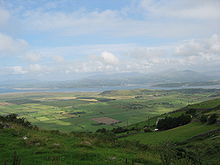
The county contains much of Snowdonia (Eryri), a national park which contains Wales's highest mountain, Snowdon (Yr Wyddfa; 3,560 feet, 1,090 m).
During the Industrial Revolution the slate industry rapidly developed; in the late nineteenth century the neighbouring Penrhyn and Dinorwic quarries were the largest in the world, and the Slate Landscape of Northwest Wales is now a World Heritage Site.
In the past, historians such as J. E. Lloyd assumed that the Celtic source of the word Gwynedd meant 'collection of tribes' – the same root as the Irish fine, meaning 'tribe'.
Venedotia was the Latin form, and in Penmachno there is a memorial stone from c. AD 500 which reads: Cantiori Hic Iacit Venedotis ('Here lies Cantiorix, citizen of Gwynedd').
The Local Government (Wales) Act 1994 abolished the 1974 county (and the five districts) on 1 April 1996, and its area was divided: the Isle of Anglesey became an independent unitary authority, and Aberconwy (which included the former Denbighshire parishes) passed to the new Conwy County Borough.
As a unitary authority, the modern entity no longer has any districts, but Arfon, Dwyfor and Meirionnydd remain as area committees.
A significant part of the county lies within the Snowdonia National Park, which extends from the north coast down to the district of Meirionnydd in the south.
Industries which have developed more recently include TV and sound studios: the record company Sain has its HQ in the county.
[10] The Annual Population Survey estimated that as of March 2023, 77.0% of those in Gwynedd aged three years and above could speak Welsh.