Hạ Long Bay
[7] Hạ Long Bay also marked some important events in Vietnamese history, with many artifacts found in Bài Thơ mountain, Đầu Gỗ cave, and Bãi Cháy.
[7] Nguyễn Trãi praised the beauty of Hạ Long Bay 500 years ago in his verse Lộ nhập Vân Đồn, in which he called it "a rock wonder in the sky".
[8] In 1962, the Ministry of Culture, Sports and Tourism of North Vietnam listed Hạ Long Bay in the National Relics and Landscapes publication.
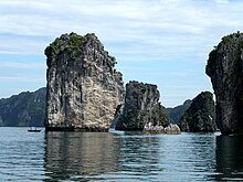
[11] The bay consists of a dense cluster of some 1,600[10] limestone monolithic islands each topped with thick jungle vegetation, rising spectacularly from the ocean.
Residents of the bay mostly live on boats and rafts buoyed by tires and plastic jugs to facilitate the fishing, cultivating and breeding of aquatic and marine species.
Residents of the floating villages around Hạ Long Bay now offer bedrooms for rent, boat tours, and fresh seafood meals to tourists.
], the Quảng Ninh provincial government has a policy to relocate the households living in the bay to resettle, in order to stabilize their life and to protect the landscape of the heritage zone.
[13] During the Vietnam War, many of the channels between the islands were heavily mined by the United States Navy, some of which continue to pose threats to shipping routes in the present day.
Hạ Long Bay and its adjacent areas consist of a part of the Sino-Vietnamese composite terrane having its development history from pre-Cambrian up to present day.
During Phanerozoic, terrigenous, volcanogenic and cherty-carbonate sediments containing in abundance graptolites, bivalves, brachiopods, fishes, foraminiferans, corals, radiolarias, and flora, separated from one from another by 10 stratigraphic gaps, but the boundary between Devonian and Carboniferous has been considered as continuous.
The present Hạ Long Bay, in fact, appeared after the Middle Holocene maximum transgression, leaving ultimate zone of lateral undercutting in the limestone cliffs bearing many shells of oysters, having the 14C age as 2280 to >40,000 y. BP.
In the alkaline seawater environment, the chemical denudation process of calcium carbonate proceeds rapidly, creating wide, strangely shaped marine notches.
The intertidal zone sediments are various, from clay mud to sand and gravel, depending on distinguished sedimentary environments such as mangrove marshes, tidal flats, beaches etc.
The sediment layers of the intertidal zone, the upper sea bed with a plain surface conserving ancient rivers, the systems of caves and their sediments, traces of ancient marine action forming distinctive notches, beaches and marine terraces, and mangrove swamps are important evidence of geological events and processes taking place during the Quaternary Period.
[16] Due to a simultaneous combination of ideal factors such as thick, pale, grey, and strong limestone layers, which are formed by fine-grained materials; hot and moist climate and slow tectonic process as a whole; Hạ Long Bay has had a complete karst evolution for 20 million years.
The sequence of stages in the evolution of a karst landscape over a period of 20 million years requires a combination of several distinct elements including a massive thickness of limestone, a hot wet climate and slow overall tectonic up lift.
Within Hạ Long Bay, the main accessible caves are the older passages that survive from the time when the karst was evolving through its various stages of fengcong and fenglin.
Trinh Nu, which is one of the larger foot caves in Hạ Long Bay with its ceiling at about 12m above sea level and about 80m in length, was developed in multiple stages.
If these karst landscapes are broadly compared in terms of their height, steepness and number of their limestone towers, Hạ Long Bay is probably second in the entire world only to Yangshuo, in China.
[19] The many islands that dot the bay are home to a great many other species, including (but likely not limited to): 477 magnoliales, 12 pteris, 20 salt marsh flora; and 4 amphibia, 10 reptilia, 40 aves, and 4 mammalia.
Local government and businesses are aware of the problems and many measures have been taken to minimise the impact of tourism on the bay environment for sustainable economic growth like introducing eco-friendly tours and tight waste control on resorts.
The economic growth in these urban areas, coupled with the rapid rise of the southern regions in China, including Hong Kong, have led to increasing human pressures on Ha Long Bay.
[5] The coastal areas of Quang Ninh province and Hai Phong City have experienced rapid growth in infrastructure development, particularly in transportation, shipping, coal mining, and tourism-related industries.
Some argue that there is a need for cautious consideration of development in the bay area through effective management structures, given its crucial environmental significance for the entire region.
[5] Currently, the expansion of urban areas and population growth, construction of ports and factories, tourism and service activities, household and industrial waste, fishing and aquaculture practices, have not only become threats but have also caused alarming levels of environmental pollution and landscape changes in Ha Long Bay.
"[28] Additionally, as Ha Long Bay is surrounded by thousands of limestone islands, which are mostly good construction materials, they are susceptible to private exploitation, leading to landscape distortion.
[29] On another aspect, global climate change with rising sea levels will strongly impact the landscape, island systems, caves, and biodiversity of Ha Long Bay.
Additionally, the province has relocated fishing households living on floating villages to the mainland to protect the water environment of Ha Long Bay.
[34] In the bay area, some local residents have voluntarily taken action to preserve the landscape by organizing volunteer groups to collect and handle waste.
[35] Starting from September 1, 2019, the People's Committee of Ha Long City strictly banned the use of single-use plastic products in the bay area.