Hardangervidda National Park
Designated as a national park in 1981, today it serves as a popular tourist destination for activities such as hiking, climbing, fishing, and cross-country skiing.
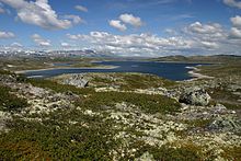
The plateau is the largest peneplain (eroded plain) in Europe, covering an area of about 6,500 km2 (2,500 sq mi) at an average elevation of 1,100 metres (3,600 ft).
The landscape of the Hardangervidda is characterised by barren, treeless moorland interrupted by numerous pools, lakes, rivers and streams.
The Hardangervidda has been occupied for thousands of years; several hundred nomadic Stone Age settlements have been found in the area, most likely related to the migration of the reindeer.
June/July to September/October is great for hiking, fishing, wildlife viewing, cycling, horseback riding, canoeing, hunting and other summer activities.
The Norwegian Trekking Association offers a network of hiking paths and cabins connecting Hardangervidda from Haukeliseter and Mogen in the south to Finse in the north, Rjukan and Geilo in the east and Eidfjord and Odda in the west.
At night on 26 August 2016, 323 wild reindeers, including 70 calves, were killed by lightning during a storm, when they stood in the grasses of the Hardangervidda plateau.