Hatay Province
[5] Settled since the early Bronze Age, Hatay was once part of the Akkadian Empire, then of the Amorite Kingdom of Yamhad.
Later, it became part of the Kingdom of Mitanni, then the area was ruled by a succession of Hittites and Neo-Hittite peoples that later gave the modern province of Hatay its name.
The region was the centre of the Hellenistic Seleucid Empire, home to the four Greek cities of the Syrian tetrapolis (Antioch, Seleucia Pieria, Apamea, and Laodicea).
Seljuk rule lasted 14 years until Hatay's capture by the Crusaders in 1098, when parts of it became the centre of the Principality of Antioch.
At the same time, much of Hatay was part of the Armenian Kingdom of Cilicia, who subsequently allied with the Mongols and took control of the Principality of Antioch in 1254.
Hatay was captured from the Mongol-Armenian alliance by the Mameluks in 1268, who subsequently lost it to Timur (Tamerlane) at the start of the 15th century.
By the time it was taken from the Mameluks by the Ottoman Sultan Selim I in 1516, Antakya was a medium-sized town on 2 square kilometres (0.77 sq mi) of land between the Orontes River and Mount Habib Neccar.
[7] During the First World War, most of Syria was occupied by the British but under the Armistice of Mudros, Hatay remained part of the Ottoman Empire.
It was placed under the French mandate of Syria after the Allies and Turkey signed the Treaty of Sèvres, which was neither ratified by the Ottoman parliament nor by the Turkish National Movement in Ankara.
The document detailing the boundary between Turkey and Syria around 1920 and subsequent years is presented in a report by the Official Geographer of The Bureau of Intelligence and Research of the US Department of State.
This was due to the contested nationalist pseudoscientific Sun Language Theory prevalent in the 1930s in Turkey, which presumed that some ancient peoples of Anatolia and the Middle East, such as the Sumerians and Hittites, hence the name Hatay, were related to the Turks.
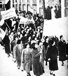
The 1936 elections returned two MPs favouring the independence of Syria from France, and this prompted communal riots as well as passionate articles in the Turkish and Syrian press.
Under its new statute, the sanjak became "distinct but not separated" from the French mandate of Syria on the diplomatic level, linked to both France and Turkey for defence matters.
This referendum has been labelled both "phoney" and "rigged", and is seen as a way for the French to cede the area to Turkey, in the hope that they would turn on Hitler.
Many of these Armenians had fled for their lives and settled in the French Mandate of Syria because they were survivors of the genocide which had previously been committed by the Ottoman Empire.
[19][20] For much of its premodern history, Alexandretta, with its capital city Antioch, was considered as part of Bilad al-Sham, the area known today as Syria.
In 1936 Alexandretta became the subject of a complaint to the League of Nations by Turkey, which claimed that the privileges of the Turkish plurality in the sanjak were being infringed.
Unlike other regions historically belonging to Syrian provinces (such as Aintab, Kilis and Urfa), Alexandretta was confirmed as Syrian territory in the Treaty of Lausanne agreed upon by Kemal Atatürk but was granted a special autonomous status because it contained a Turkish plurality.
Syrians hold the view that this land was illegally ceded to Turkey by France, the mandatory occupying power of Syria in the late 1930s.
Syrians call this land Liwa' aliskenderun (Arabic: لواء الاسكندرون) rather than the Turkish name of Hatay.
As part of the ongoing war, the question of the sovereignty of Hatay has resurfaced in Syria and the Syrian media silence has been broken.
Syrian media began broadcasting documentaries on the history of the area, the Turkish annexation and Turkification policies.
Syrian newspapers have also reported on demonstrations in Hatay and on organizations and parties in Syria demanding an "end to the Turkish occupation".
The most prominent feature is the north-south leading Nur Mountains and the highest peak is Mığırtepe (2,240m), other peaks include Ziyaret dağı and Keldağ (Jebel Akra or Casius) at 1,739 m. The folds of land that make up the landscape of the province were formed as the land masses of Arabian-Nubian Shield and Anatolia have pushed into each other, meeting here in Hatay, a classic example of the Horst–graben formation.
There are some mineral deposits, İskenderun is home to Turkey's largest iron and steel plant, and the district of Yayladağı produces a colourful marble called Rose of Hatay.
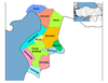
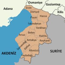
Hatay province is divided into 15 districts,[40] listed below with their populations officially estimated as at 31 December 2022:[1] The majority of the population adheres to either Sunni Islam or Alawism, but other minorities are also present, including Syriac Orthodox, Syriac Catholic, Maronite, Antiochian Greek and Armenian communities.
[42][43] Arabs form the majority in three districts out of the twelve: Samandağ (Suwaidiyyah) (Alawi), Altınözü (Qusair) and Reyhanlı (Rihaniyyah) (Sunni).
[46] As of 2016, 85% of Arabic-heritage-speaking people in relevant parts of Hatay, specifically those who hear and may use the language on a daily basis, believed its use was decreasing; the rest disagree.


• Turkish
• Arabic speakers are shown by religious affiliation: Alawite (circle), Christian (triangle), Sunni (square), Bedouin Sunni (rectangle), Jewish (rhombus). [ 41 ] [a]