Hawaii hotspot
One of the best known and intensively studied hotspots in the world,[1][2] the Hawaii plume is responsible for the creation of the Hawaiian–Emperor seamount chain, a 6,200-kilometer (3,900 mi) mostly undersea volcanic mountain range.
After the arrival of Europeans on the island, in 1880–1881 James Dwight Dana directed the first formal geological study of the hotspot's volcanics, confirming the relationship long observed by the natives.
[1] This cycle of growth and dormancy strings together volcanoes over millions of years, leaving a trail of volcanic islands and seamounts across the ocean floor.
According to Wilson's theory, the Hawaiian volcanoes should be progressively older and increasingly eroded the further they are from the hotspot, and this is easily observable; the oldest rock in the main Hawaiian islands, that of Kauaʻi, is about 5.5 million years old and deeply eroded, while the rock on Hawaiʻi Island is a comparatively young 0.7 million years of age or less, with new lava constantly erupting at Kīlauea, the hotspot's present center.
Supporters of this hypothesis argue that the wavespeed anomalies seen in seismic tomographic studies cannot be reliably interpreted as hot upwellings originating in the lower mantle.
It is possible, as supported by gravitational modelling, that during this period that the Hawaii hotspot drifted about 4-9 degrees to the south, in contrast to the northward Pacific Plate movement.
[7][24] Lead scientist John Tarduno told National Geographic: The Hawaii bend was used as a classic example of how a large plate can change motion quickly.
"[24]Despite the large shift, the change in direction was never recorded by magnetic declinations, fracture zone orientations or plate reconstructions; nor could a continental collision have occurred fast enough to produce such a pronounced bend in the chain.
[25] To test whether the bend was a result of a change in direction of the Pacific Plate, scientists analyzed the lava samples' geochemistry to determine where and when they formed.
While hot lava from a volcanic eruption cools, tiny grains within the magnetite align with the Earth's magnetic field, and lock in place once the rock solidifies.
During their voyages, seafaring Hawaiians noticed differences in erosion, soil formation, and vegetation, allowing them to deduce that the islands to the northwest (Niʻihau and Kauaʻi) were older than those to the southeast (Maui and Hawaiʻi).
Pele was born to the female spirit Haumea, or Hina, who, like all Hawaiian gods and goddesses, descended from the supreme beings, Papa, or Earth Mother, and Wakea, or Sky Father.
[30] American geologist James Dwight Dana was on that expedition, as was Lieutenant Charles Wilkes, who spent most of the time leading a team of hundreds that hauled a Kater's pendulum to the summit of Mauna Loa to measure gravity.
The facility was taken over in 1919 by the National Oceanic and Atmospheric Administration and in 1924 by the United States Geological Survey (USGS), which marked the start of continuous volcano observation on Hawaii Island.
Since that time, advances (e.g. improved rock dating methods and submarine volcanic stages) have enabled the study of previously limited areas of observation.
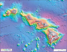
[36][37] From 1994 to 1998[38] the Japan Agency for Marine-Earth Science and Technology (JAMSTEC) mapped Hawaii in detail and studied its ocean floor, making it one of the world's best-studied marine features.
[46] The low heat across the Hawaiian Swell indicates that it is not supported by a buoyant crust or upper lithosphere, but is rather propped up by the upwelling hot (and therefore less-dense) mantle plume that causes the surface to rise[45] through a mechanism known as "dynamic topography".
The 2001[49] expedition drilled six seamounts and tested the samples to determine their original latitude, and thus the characteristics and speed of the hotspot's drift pattern in total.
It is also possible that a collision near the Aleutian Trench had changed the velocity of the Pacific Plate, explaining the hotspot chain's bend; the relationship between these features is still being investigated.
The most rapid decrease in elevation and the highest ratio between the topography and geoid height are over the southeastern part of the chain, falling with distance from the hotspot, particularly at the intersection of the Molokai and Murray fracture zones.
The tsunami reportedly rolled over the tops of the coconut trees up to 60 ft (18 m) high and it reached inland a distance of a quarter of a mile (400 m) in some places.
[61] The higher magnitude earthquakes are derived from the basal (decollement) layer being influenced by deformities caused by the increased weight of the Hawaiian islands.
[62] Such modelling to explain observed eathquake patterns suggests the concept that a soft center hole exists under the island of Hawaiʻi where the lithospheric Pacific plate is broken.
[64] Hawaiian volcanoes are characterized by frequent rift eruptions, their large size (thousands of cubic kilometers in volume), and their rough, decentralized shape.
Rapidly moving avalanches carried 10 km (6 mi) blocks tens of kilometers away, disturbing the local water column and causing a tsunami.
[23] GPS measurements on the eastern flank of Hawaii Island over a 5 year epoch show the pattern of collapse with velocities of up to 15 cm/year (5.9 in/year) relative to the Pacific Plate[71] Hawaiian volcanoes follow a well-established life cycle of growth and erosion.
The lava released in this stage often includes both pāhoehoe and ʻaʻā, and the currently active Hawaiian volcanoes, Mauna Loa and Kīlauea, are in this phase.
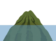
After the subaerial phase the volcano enters a series of postshield stages involving mechanical collapse creating subsidence and erosion, becoming an atoll and eventually a seamount.
[75] These fringing reefs gradually accrete vertically and seaward as an inactive volcano subsides, coinciding with a rise in relative sea level.
A modern example, Kailua Bay off Oahu Hawaii, has been studied extensively to understand reef carbonate generation, sediment production and deposition.