List of secondary highways in Algoma District
This is a list of secondary highways in Algoma District, most of which serve as logging roads or provide access to isolated and sparsely populated areas in the Algoma District of northeastern Ontario.
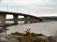
Some of the shorter ones are also access routes for communities with moderate amounts of tourism, most famously St. Joseph Island's highway 548.
The route connects several mining and milling towns in Unorganized Algoma District, notably Searchmont.
The route is remote, ending at a mine access road 14.2 kilometres (8.8 mi) north of Highway 556, its southern terminus.
The highway connects the hamlets of Richard's Landing and Hilton Beach, and guides tourists to Fort St. Joseph.
The remainder of the route is built to secondary highway standards, with a single solid centerline throughout.
Highway 550 continues to its western terminus, at a roundabout on the shores of Lake Superior, in Gros Cap.
The MTO maintains the 9.1 km (5.7 mi) portion of Highway 550 west of Town Line Road.
A 2.2 km (1.4 mi) section of Second Line between Carmen's Way and Highway 17 (Great Northern Road) is maintained under a Connecting Link agreement.
[4] The remainder, between Town Line Road and Carmen's Way, is maintained by the city of Sault Ste.
In 1991, the Ministry of Transportation issued a report which proposed that the route be extended to meet Spine Road in Elliot Lake,[5] creating an alternate route which would reduce the length of a commute between Elliot Lake and Blind River by approximately 20 kilometres compared to the current routes of Highway 17 and Highway 108.
[5] While the ministry has not announced a plan to proceed with the construction, in 2015 Elliot Lake's city council passed a motion calling for the project to be revived.
Its western terminus is at Highway 17 in the hamlet of Heyden, just north of Sault Ste.
Despite its relatively poor surface, it is considered an alternate link between Chapleau and Sault Ste.
Commencing at a junction with Highway 17 in the town of Blind River, the highway extends northerly for 22.9 km (14.2 mi) to the shore of Matinenda Lake, providing the primary road access to Matinenda Lake Provincial Park as well as to rural parts of the town of Blind River and the neighbouring Mississauga First Nation.
Batchawana Bay has a church, post office, elementary school, motel, and homes for the permanent residents, among them First Nations people.
Originally, Highway 565's southern terminus was the intersection of Point-Aux-Pins Road, near the St. Mary's River.
[6]: 90 Surveying for the southern section began in 1962;[7]: 45 the highway was completed at a cost of $7.5 million,[7]: 48 and opened on May 26, 1973.
The White River terminus became a subject of brief controversy after it was rerouted to meet Highway 17 within property owned by the town's mayor, Naldo Bracci.
There are no services available nor any development along its entire length except at Hornepayne, the only community situated on it, about 100 kilometres (60 mi) from White River.
The highway measures 52.1 kilometres (32.4 mi) in length, extending from Echo Bay eastward through the communities of Sylvan Valley, Leeburn and Ophir, where it turns southward and runs south through Rydal Bank, Bruce Station, and finally to its southeastern terminus, also at Highway 17, in the town of Bruce Mines.
The highway does not link the city to any significant residential settlements, but is used primarily as an access road to Mississagi Provincial Park and a few recreational lodges.
Highway 651 was established on Centennial anniversary of Confederation, but did not connect to any other roads originally; access to the route was provided from Missanabie.