Highway location marker
Unlike traditional milestones, however, which (as their name suggests) were originally carved from stone and sited at one-mile intervals, modern highway location markers are made from a variety of materials and are almost invariably spaced at intervals of a kilometre or a fraction thereof (except in the United States, where miles are used on roadways).
Other ancient highway names include The Pilgrims Way, Watling Street and the Via Appia.
However, with the increase in private traffic after the First World War a simpler way of identifying roads was needed.
The advent of motorways meant an extension to both the British and the French methods of roads identification.
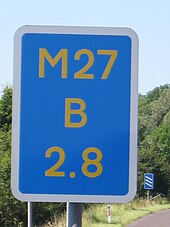
This has led to the erection of driver location signs in England (but at the time of writing, not in Scotland, Wales or Northern Ireland)[4] at about 500 metre (about 1/3 mile) intervals on many motorways.
[5] The letter "A" normally denotes the carriageway in the direction of increasing location numbers (usually away from London), "B" the carriageway in the direction of decreasing location numbers while "J", "K", "L" and "M" denote junction slip roads.
Location reference indicator (LRI) signs are provided on motorways and dual carriageway national roads.
In addition to showing the motorway number and location, they also bear a carriageway identifier – Li for Links (Left) and Re for Rechts (Right).
The carriageways are identified as being left-hand and right-hand as viewed by somebody looking in the direction of increasing location numbers.
By and large, Dutch location numbers increase as one moves away from Amsterdam, or in the case of roads that do not originate in Amsterdam, location numbers increase as one moves eastwards away from the North Sea.
Many states have added supplemental reference markers that indicate distance in fractional miles (tenth, quarter, half, etc.)
Multiple other states, including Nevada, Ohio, and Tennessee, use similar county-based mile markers on non-interstates, but use standard mileposts on interstate routes.
The routes were marked by a yellow rectangular sign with black numbers and border.
[8] In 1926, several of the routes were supplanted by the national United States Numbered Highway System.
The marker illustrated carries the following information: Although the sign illustrated uses Latin script, a number of Indian location markers use the Indian official language Hindi or the predominant language of the state in which they are located.
In the Consolidated Law Regulation of 1959, figure 103b mentions the use of the motorway confirmation sign, consisting of a white box on the left with the distance from the point of origin of the road and a blue rectangle with white characters in which the name of the next exit is shown with the relative distance in kilometers.
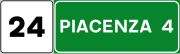
In Italy the highway location marker is a square white sign with the current kilometer (of hectometer) of the road written on it.
They include the route code, location number from the road starting point and sometimes direction of the carriageway.
On the other hand, federal roads have marker which are placed every kilometre and includes the distance to primary destination and location number.
The style of the route marker, apart from the green E-route indicator, is specific to the country concerned.