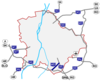
Highways in Hungary
The first domestic design for the creation of automobile roads (autómobil utak, autómobil-pályák) was the work of Boldizsár Vásárhelyi, who prepared the first professional concept in 1941 as his doctoral dissertation.
Although this draft would not have eliminated the radial structure starting from Budapest, it would have emphasized the highway in places where there is no main road.
For example: to the east between Main roads 3 and 4 as the crow flies towards Debrecen, to the south between Highway 5 and the Danube straight towards Újvidék and Belgrade, to Zagreb further south from Highway 7, thus avoiding Lake Balaton further away, Tab and in the area of Marcali, and also towards Vienna by straightening Main road 1 towards the southern bypass of Tata.
The project envisaged the construction of 2,000 km of automobile roads on the then twice the national area, essentially including today's outer ring.
However, the rigid way of thinking of the concept makers of the era left the spatial structure of Hungary unchanged in essential points: the outlined highway network is centered on Budapest, and the roads cross the major rivers (e.g. Danube and Tisza) exactly where bridges already stood at the time the plan was prepared.
In essence, the above was confirmed by the fact that in 1978, the transformation of the radial structure of the main road network into a ring-radial system was already included as a directive in the new transport policy concept.
In 1988, the need to create European-standard connections to the north–south and east–west transit traffic flow directions already appeared among the priority tasks.
This is also reflected in the maturing changes in the international situation, the logical consequence of which in the high-speed network is the adoption of an opening grid structure.
The National Road Network Development Program for the years 1991–2000, adopted in 1991, supported the development of radial and transverse roads, but did not consider the southern highway (Déli autópálya), which is increasingly emerging thanks to the activities of lobbyists, to be feasible.
This one is an important route of the Hungarian highway and road network, the northern diagonal main line of traffic forming part of Budapest.
This is one of the most important route of the Hungarian motorway and road network, the southwest–north-eastern diagonal main line of traffic forming part of Budapest.
The M5 motorway starts from Budapest, it connects the Hungarian capital with Szeged and southeast part of Hungary, towards Belgrade.
The M6 motorway starts from Budapest (M0-M6 Interchange), it connects the Hungarian capital with Dunaújváros, Szekszárd and Mohács, on the right bank of the Danube, towards Osijek and Sarajevo.
Main junctions: The M7 motorway starts from Budapest, it connects the Hungarian capital with Lake Balaton and southwestern part of Transdanubia, towards to Zagreb.
Main junctions: Construction of new motorways in recent years has been hampered due to corruption scandals and austerity measures as well as owing to new European rules under which old EIA assessments lapsed.
Contracted segments with estimated openings:[7] Hungarian highways network since 1964 The Hungarian system has 2 main type in terms of salary (for motorcycles, passenger cars, buses, trailers, vans up to 3.5 t): All vehicles must have an electronic vignette to use the motorways and expressways in Hungary.
[11] A blue motorway or expressway road sign means that a paid e-vignette toll is obligatory unless stated otherwise (usually sections from the border to the closest exit).
[14] There are several dual carriageway main road sections in Hungary, which are similar in most technological respects to expressways but allow at-grade intersections.