Geology of the Himalayas
The geology of the Himalayas is a record of the most dramatic and visible creations of the immense mountain range formed by plate tectonic forces and sculpted by weathering and erosion.
The Himalaya-Tibet region supplies fresh water for more than one-fifth of the world population, and accounts for a quarter of the global sedimentary budget.
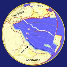
During Late Precambrian and the Palaeozoic, the Indian subcontinent, bounded to the north by the Cimmerian Superterranes, was part of Gondwana and was separated from Eurasia by the Paleo-Tethys Ocean (Fig.
During that period, the northern part of India was affected by a late phase of the Pan-African orogeny which is marked by an unconformity between Ordovician continental conglomerates and the underlying Cambrian marine sediments.
In the Late Cretaceous (84 Ma), the Indian plate began its very rapid northward drift covering a distance of about 6000 km,[6] with the oceanic-oceanic subduction continuing until the final closure of the oceanic basin and the obduction of oceanic ophiolite onto India and the beginning of continent-continent tectonic interaction starting at about 65 Ma in the Central Himalaya.
The mid-crustal ramp in the Himalayas is a key geologic feature in the history for both long-term and short-term seismic processes linked to deformation and shortening.
Over the last 15 Ma, the ramp has gradually moved south due to duplexing, accretion, and tectonic undercutting.
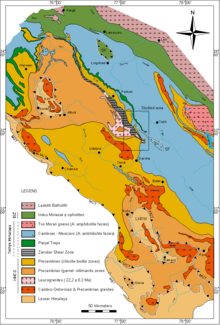
It forms the southern foothills of the Himalayan Range and is essentially composed of Miocene to Pleistocene molassic sediments derived from the erosion of the Himalaya.
The Lesser Himalaya (LH) tectonic plate is mainly formed by Upper Proterozoic to lower Cambrian detrital sediments from the passive Indian margin intercalated with some granites and acid volcanics (1840 ±70 Ma[17]).
Although most of the metasediments forming the HHCS are of late Proterozoic to early Cambrian age, much younger metasediments can also be found in several areas, e.g. Mesozoic in the Tandi syncline of Nepal and Warwan Valley of Kistwar in Kashmir, Permian in the "Tschuldo slice", Ordovician to Carboniferous in the "Sarchu area" on Leh-Manali Highway.
It is now generally accepted that the metasediments of the HHCS represent the metamorphic equivalents of the sedimentary series forming the base of the overlying "Tethys Himalaya".
The Tethys Himalaya is an approximately 100-km-wide synclinorium formed by strongly folded and imbricated, weakly metamorphosed sedimentary series.
The transition between the generally low-grade sediments of the "Tethys Himalaya" and the underlying low- to high-grade rocks of the "High Himalayan Crystalline Sequence" is usually progressive.
The Lamayuru and Markha Units are formed by flyschs and olistholiths deposited in a turbiditic environment, on the northern part of the Indian continental slope and in the adjoining Neotethys basin.
The first model includes slab tear where the lower plate tore off into the mantle leading to high amounts of rebound.
The second model states that the rocks got to a certain point in subduction and then were forced back up through the channel they came down due to a space problem.
The third model states that the thick continental crust of India further exacerbated the space problem and caused the corner flow of those rocks back up the channel.
This suture zone is formed by: The modern day rate of convergence between the Indian and Eurasian plates is measured to be approximately 17 mm/yr.