The territory of the United States and its overseas possessions has evolved over time, from the colonial era to the present day.
The last section lists informal regions from American vernacular geography known by popular nicknames and linked by geographical, cultural, or economic similarities, some of which are still in use today.
The following are land grants, cessions, defined districts (official or otherwise) or named settlements made within an area that was already part of a U.S. state or territory that did not involve international treaties or Native American cessions or land purchases.
These entities were sometimes the only governmental authority in the listed areas, although they often co-existed with civil governments in scarcely populated states and territories.
Some were enclaves within enemy-held territories: These were regions disassociated from neighboring areas due to opposing views: Belts are loosely defined sub-regions found throughout the United States that are named for a perceived commonality among the included areas, which is often related to the region's economy or climate.
National Atlas
map of United States territorial acquisitions
Map showing mid 17th century claims and land grant boundaries. Some colonies seen here are: Nova Scotia (NSc), Territory of Sagadahock (TS), First Province of Maine (Me), New Hampshire (NH), Plymouth (PC), Massachusetts Bay (MBC), New Netherland (NN), New Sweden (NSw), and Lord Baltimore's Land (Md; Maryland)
French settlements and forts in the so-called Illinois Country, 1763, which encompassed parts of the modern day states of Illinois, Missouri, Indiana and Kentucky)
A 1775 map of the
German Coast
, a historical region of present-day Louisiana located above
New Orleans
on the eastern bank of the Mississippi River
Vandalia
was the name of a proposed British colony located south of the Ohio River, primarily in what is now the U.S. states of West Virginia and eastern Kentucky
A proposal for the creation of
Westsylvania
was largely deterred by the Revolutionary War
Map showing North American territorial boundaries leading up to the
American Revolution
and the founding of the
United States
:
British
claims are indicated in red and pink, while Spanish claims are in orange and yellow.
The Oregon Country. The dispute over Oregon, between Britain and the U.S., led to an uneasy, parallel governing of the territory for almost 30 years.
Seward's Folly
. The controversial purchase of Alaska from
Russia
in 1867 turned out to be a great deal for the U.S. when the area proved to contain a treasure trove of natural resources.
The Baton Rouge and Mobile Districts of
Spanish West Florida
, claimed by the United States, spanned parts of three later states. The Spanish province also included part of the present-day state of Florida.
The first state cessions. The 13 original states ceded their western claims to the federal government, allowing for the creation of the country's first western territories and states.
The Northwest Territory was ceded by Great Britain to the United States at the end of the
American Revolutionary War
. Britain irrevocably ceded all claims to the territory in the 1814
Treaty of Ghent
.
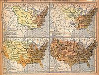
United States territorial expansion since 1803, maps by William R. Shepherd (1923)
Census Bureau map depicting territorial acquisitions and effective dates of statehood
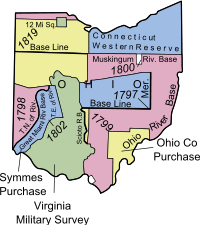
Map of Military Reserves in the United States, 1778–1816, with Dates of Creation
The Ohio Country, indicating battle sites between settlers and
Native American Tribes
, 1775–1794
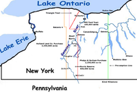
Selected tract purchases of western New York State