Aruba
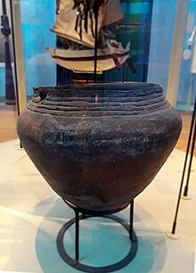
[17] During this period, the Leeward Islands maintained connections and engaged in trade with mainland South America, particularly with partners in the present-day Falcón-Zulia state in Venezuela and possibly the La Guajira Peninsula (Venezuela/Colombia).
[15] The area over which the legendary cacique Manaure exercised his authority was the coastal region of the current state Falcón-Zulia at Venezuela, including the Paraguaná Peninsula, as well as Aruba, Curaçao and Bonaire.
They were situated in places where beneficial agriculture land was available and where the most favorable hydrological conditions prevailed, such as where several rooi (gullies) came together and where relatively much water was available.
India had been the spearhead of European trade expansion and the foreign policy of the Spanish Crown since the travels of Marco Polo a century earlier.
India, China, and Japan formed the focal point of medieval ideas about boundless riches, cities with houses covered in gold, and islands with inexhaustible amounts of spices, pearls, and silk.
The newly appointed Spanish Pope Alexander VI issued the Inter Caetera bull, granting the Spanish Crown sovereignty over the newly discovered territories and the responsibility of the holy task: to send good, God-fearing men, who are earned and capable, to those islands and continents to teach the natives living there about the Catholic faith and instill in them good habits.
The conquest was characterized by bloodshed, destruction, and forced assimilation of the native peoples into European society, such as the initiation of Indian slavery by Columbus in 1492.
While expedition leaders mostly came from the higher echelons of late medieval society, their foot soldiers were usually from the lower middle class of southern Europe.
For example, indigenous communities had to give up a portion of the yields from their agricultural or farm land, known as conucos in Taino,[a] as a form of taxation and to provide for the food supply of the colonists.
De Ojeda established a base named Santa Cruz at the tip of Guajira, from whence he conducted trade and, probably even more importantly, carried out his raids, including slave hunts.
After an unsuccessful attempt by Bartolomé de Las Casas to convert the local population to Christianity, the coastal region of the mainland was leased to the banking firm of the Welsers in 1528.
Most of the islands remained largely uncontrolled and undefended, making them a potential opportunity for northwestern European countries that wanted to break Spain's monopoly on colonizing the New World.
In the Falcón-Zulia province, among other places, Caquetío societies survived on Tierra Firme, although their cultures and social structures were largely destroyed by the Spaniards.
The Dutch were compelled to venture into forbidden waters of the Caribbean, known as Spain's mare clausum, because of their need for salt, in open defiance of Phillip II.
[41] After hostilities resumed, the Dutch established the West India Company (WIC) with the main objective of engaging in strategic military actions and privateering organization against Spain.
In 1623, the first official fleet of the new WIC, a small squadron of only three ships commanded by Pieter Schouten, set sail for the Caribbean to engage in looting and plundering in the Lesser Antilles and the Yucátan peninsula.
For example, when the islands faced famine due to a series of dry seasons, Stuyvesant came to the rescue by sending a ship with food just in time.
At that time, even though a war between England and the United Provinces had not been officially declared, an English fleet led by Richard Nicolls demanded that New Amsterdam surrender.
Colonists exerted control over Indians on the "useless islands", mirroring the hardships of these faced by subsequent African slaves, marked by a denial of freedom and forced labor.
[47] After 1775 the names of African slaves began appearing in records, with examples such as "Cecilia" and "Apolinar" tied to families like Silvester and Alvarez from Alto Vista near the coast.
[52] Croes later met with Dutch Prime Minister Joop den Uyl, with the two sides agreeing to assign the Institute of Social Studies in The Hague to prepare a study for independence, entitled Aruba en Onafhankelijkheid, achtergronden, modaliteiten, en mogelijkheden; een rapport in eerste aanleg (Aruba and independence, backgrounds, modalities, and opportunities; a preliminary report) (1978).
[52] In March 1983 Aruba reached an official agreement within the kingdom for its independence, to be developed in a series of steps as the Crown granted increasing autonomy.
[61] This region is marked by rolling hills, including Jamanota, and is home to Arikok National Park, and limestone terraces surround these two landscapes.
The low-lying limestone terrace regions are defined by their white sandy beaches and the high plateaus on the north side of the island, in contrast, are constantly battered by the rough waters of the ocean, featuring caves and small natural bridge formations.
In terms of country of birth, the population is estimated to be 66% Aruban, 9.1% Colombian, 4.3% Dutch, 5.1% Dominican, 3.2% Venezuelan, 2.2% Curaçaoan, 1.5% Haitian, 1.2% Surinamese, 1.1% Peruvian, 1.1% Chinese, 6.2% from other backgrounds.
Each year, on February 11 (the feast of Lady Lourdes), a procession departs from St. Theresita Church in San Nicolas and heads to the grotto, where a Mass is held.
[103] The education landscape includes a mix of public and private institutions, such as the International School of Aruba,[104] the Schakel College,[105] and Colegio Arubano.
In recent years a letter of intent was signed with CITGO (the US subsidiary of the Venezuelan state oil company PDVSA) to explore the possibility of reopening the refinery again.
According to the Bureau Burgelijke Stand en Bevolkingsregister (BBSB, Civil Registry and Population Register), in 2005, the island was home to people from 92 different nationalities.
It began in the 1950s, influenced by residents from Venezuela and nearby islands (Curaçao, St. Vincent, Trinidad, Barbados, St. Maarten, and Anguilla) who worked at the oil refinery.