History of Belém
[2] Until the beginning of the sixteenth century, Portugal showed no interest in the lands located at the mouth of the Amazon River; a fact possibly linked to the policies adopted by the royal courts of the first expansionist phase, more concerned with expanding their domains along the African coast and the East.
[3] However, the succession crisis that led to the union of the courts of Portugal and Spain, coupled with the threat of pirates and smugglers in the region near the equator, implied a change of attitude beyond the Treaty of Tordesillas.
[3] The construction of a city in the middle of the Amazon rainforest was difficult regarding the change in the natural environment; colonizers faced flooded lands, intersected by streams, intense vegetation, and periods of heavy rain.
[6][11][9] In 1580, the Portuguese invaded the area through the military expedition Feliz Lusitânia commanded by Captain Castelo Branco (at the behest of the king of the Iberian Union and Philippine dynasty, Manoel I), and established a colonial nucleus[13] aiming to dominate the Amazon River, occupy the Conquista do Pará, or Empire of the Amazonas (located in the then Captaincy of Maranhão), and assure the dominance in Eastern Amazon and of the drogas do sertão (how spices from the region were called), which the foreigners disputed.
In 1627, the importance of the Haver-o-Peso warehouse increased with the creation of the first patrimonial league by orders of Governor Francisco Coelho, a portion of land donated via a letter of sesmaria[note 1] to the City Council of Belém to boost the growth of the municipality.
[33] During the Viagem Filosófica expedition, the naturalist and explorer Alexandre Rodrigues Ferreira criticized the urbanization policy implemented by military engineers in Grão-Pará and the urbanization of Belém with the obstacle of swamps (especially the Piry Lake), considering unhealthy the establishment of settlements in swampy regions near rivers and forest regions with humid climate: prone to major floods, air contamination due to decomposition of organic matter, and proliferation of diseases.
[34] Ferreira, based on the philosophy of urbanization as a form of political control (associated with the birth of social medicine and medical architecture), proposed measures to enable the urban occupation of riverbanks, such as large works of water catchment and distribution, construction of wide streets aiming at the wide circulation of air, drainage of stagnant water in flooded areas of the city, construction of navigation and irrigation canals.
[34] The governor of the state of Pará implemented quarantines for the treatment of slaves arriving on the ships with smallpox, scurvy, and scabies, who were sent to the São José Hospice (1749), established in a location away from the city.
Afraid of the threat, the Portuguese did not react, and the province of Grão-Pará (covering the current states of Pará, Amazonas, Amapá, Roraima, and Rondônia) was incorporated into the Empire of Brazil on the 15th of that month.
[42][43] It happened due to the extreme poverty and diseases in Pará, which marked the beginning of this period; the late recognition of Brazil's independence (1822), and the despising of the region by prince regent Pedro I, strengthening the link with Portugal.
[42] In 1835, the Cabanos, commanded by Antônio Vinagre, invaded the government palace in Belém and executed the then-president of the province, Bernardo Lobo de Sousa, along with other authorities.
[44] In this period photography began to have a greater presence and diffusion in Belém with the contribution of the Portuguese photographer Filipe Fidanza and with the arrival of Emperor Pedro II in 1867, an encourager of this art.
Being considered one of the most developed Brazilian cities, not only for its strategic position - coastal - but also because it hosted a greater number of banking houses, "rubber barons'" residences, and other important institutions.
"[49] The application of city cleansing drove the popular sectors out of the centers and forced segregation into new peripheral neighborhoods, in the Republicans' attempt to build a "new man", a submissive but at the same time productive worker.
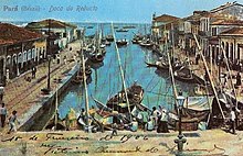
[50] Other examples are the Olympia Cinema - the oldest in Brazil in operation - one of the most luxurious and modern of the time (opened in April 1912);[47][48] the Ver-o-peso, the largest market in Latin America;[51][52][53][54] and the Batista Campos Square.
This also had the objective of attending to the new taste of the "latex elite" (especially the "rubber barons") and demonstrating to foreign investors that Belém was safe and salubrious, having the potential of becoming a financial, luxury, entertainment, and consumption center, despite most of the population being extremely poor.
[63] At this time, photography appeared as a significant element, registering the urban transformations of senator Antônio Lemos, and serving as political propaganda for the achievements of his government.
[44] These records resulted in the "Belém Album", with a cover in low relief, produced in 1902 in Paris, under the direction of Filipe Augusto Fidanza and text by Henrique Santa Rosa.
[44] Despite the intense modernization of the central neighborhoods through the rubber trade, some, such as Umarizal, still presented old/rural forms of occupation of the space, such as narrow villages, huts covered with straw or canvas, Portuguese pens, revealing the humble origins of the inhabitants.
[66] There was an increase of the built density and the accentuated elevation of the height of the buildings; new modalities of social selectivity, characterized by bold architectural projects; the incorporation of leisure equipment in the condominium area.
[66] Because they were occupied by a population considered poor and prolific, living in small precarious dwellings,[66] in occupations of disorderly structure, characterized by tortuous streets with bushes, on the muddy banks of streams and creeks.
While the central area emptied, due to the invasion of commerce and the local elite, the initial neighborhoods in the eastern zone stabilized in large blocks with wide avenues.
With the advance of the Belém-Brasília highway, started in the 1950s by President Juscelino Kubitschek, urban growth was leveraged as well as real estate expansion (in an unplanned way) in the floodplain areas, through the construction of housing and population settlements with large blocks and wide avenues.
[56][68] In 1960, the main campus of the Federal University of Pará was inaugurated in Belém and in this same year the Belém-Bragança railroad was deactivated,[69] due to the fall in revenues caused by the advance of the highways.
[56] From 1995 on, the Orla Livre Movement began, to debate the irregular occupation of the banks of the Guamá River and of the Guajará Bay, fighting for the population's rights through leisure, culture, and sports spaces, the valorization of the historical heritage, tourism, and housing, and also seeking the creation of an Integrated Management Plan for the Belém waterfront.
[72] The actions of Orla Livre intensified during the years 2012 to 2014, with the need to combat the implementation of several residential real estate projects on the banks of the Guamá River and Guajará Bay, which are Permanent Preservation Areas (APP).