History of Canberra
It was estimated by Robertson that prior to European settlement starting in 1824, depending on the season there were about 300-400 Aboriginals living in the Molonglo, Queanbeyan, Canberra, Namadgi region.
Therefore there appears to be no surviving traditional knowledge of lore, language, custom, kinship structures, oral history and genealogy associated directly with the ACT which would form the basis of a connection report.
... the historical record of Aboriginal culture and populations is very scant and contradictory, it was recognised that it would not be possible to prepare a full 'connection to country' report linking present-day people through their families and surviving traditional knowledge to the past land holding groups.
For future development, blocks for village settlements were gazetted at Pialigo, Tageranong to the south, Palmerstone to the north, and Yarrolumla to the west near the Murrumbidgee River.
The local Aboriginals of this time tended to refer to themselves as the Nyamudy people and spoke a dialect of the Ngarigo language, while the settlers called them the Limestone Plains Blacks or Pialigo Mob.
Irish-born Sir Terence Aubrey Murray, MLC, owned the Yarralumla estate (now the site of Australia's Government House) from 1837 until 1859.
Augustus Gibbes made improvements to the estate and he remained Yarralumla's resident proprietor until 1881 when he sold it to his neighbour Frederick Campbell.
The weather in the area was said to be harsh, with frosty winters and fierce hail-storm episodes, and drownings in local watercourses were a fairly common occurrence.
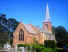
The drowning victims included the first rector of the Anglican Church of St John the Baptist, which was Canberra's first purpose-built place of worship.
The district's transformation from a New South Wales rural area to a built-up national capital began during political debates over Federation in the late 19th century.
As Victoria was relatively small in geographical area, Section 125 of the Constitution specified that the capital must be placed in a Commonwealth territory within New South Wales but at least 100 miles (160 km) from Sydney.
After an extensive search, the present site, about 300 kilometres (190 mi) south-west of Sydney, in the foothills of the Australian Alps, was chosen in 1908 as a result of survey work done by the government surveyor Charles Scrivener in that year.
[13][14] In that same year, the ACT became an alcohol-free area as a result of legislation that the Minister for Home Affairs, King O'Malley, steered through the Federal Parliament in Melbourne.
A variety of names were suggested for the capital, including Olympus, Paradise, Captain Cook, Shakespeare, Kangaremu, Sydmeladperho, Eucalypta and Myola.
Academic reconstruction of the various pronunciations by different Europeans results in a theoretical Aboriginal name for a Black Mountain peninsular camp site as Ng-aan-bira, of unknown or no meaning, in the local Nyamudy peoples dialect of the Ngarigu language.
[22]: 133 Hence from the outset, in accordance with Renaissance fashion in Britain, emphasis was placed on the picturesque, that is utilising the intrinsic beauty of the natural world, and affirmed that the future capital's landscaping and aesthetics would be just as important as its functionality.
[citation needed] Consequently, this enabled the picturesque site to act as a proxy for the "Old World's" culture, relics, and established nature which the young colony innately lacked.
[22]: 132 Hence, although Canberra is undoubtedly Australian with respect to its landscaping and wider location, the underlying motivations for these aspects "remained colonial" and "rooted" in the "Old World".
He therefore drew on the picturesque by ensuring views of the landscape and notably the wilderness of the unchartered west, which beckoned "[American] democracy's westward expansion.
"[22]: 135 The Griffins' also capitalised on an emerging theme within the new colony which recognised the bush, referring to the country's extensive native vegetation, as a national identity.
The movement was strongly implemented in the McMillan Plan, which in turn inspired Canberra's grand axes, views, and effective central focal point.
Cattle grazing near Parliament House was a common occurrence, something which amazed General Macarthur when he visited Canberra during World War II.
The responsible government minister, King O'Malley, drove the first survey peg in the Canberra area on 20 February 1913 to mark the commencement of work on the new city.
As we have seen, on 12 March that same year, the city was formally named by the Governor-General's wife, Lady Denman, at a ceremony held on Capital Hill, the site of Australia's current Parliament House.
Parts of Canberra formed the backdrop for Cold War espionage activity, highlighted during the 1954 Petrov Affair when a Soviet Union spy defected to Australia.
Canberra's residents are keen followers and participants in sports, and Bruce Stadium was opened during 1978 and later hosted several important Sydney 2000 soccer games.
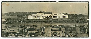
This imposing complex of parliamentary chambers, public spaces, offices and other facilities replaced the outmoded (Provisional) Parliament House that had operated close by for some 60 years.
The complex's elaborate opening ceremony was a centrepiece of Australia's bicentenary celebrations, which were held nationwide to mark the 200th anniversary of the arrival of the First Fleet from England, and the foundation of European settlement in what was to become the City of Sydney in 1788.
Major new works under construction in recent years include the Gungahlin Town Centre, City West Precinct and the Kingston Foreshores Development.
[32] As of 2005 plans were under development for a new Canberra district to be situated west of Lake Burley Griffin, on land formerly occupied by a pine plantation.