History of Jakarta
Located on an estuary of the Ciliwung River, on the northwestern part of Java, the area has long sustained human settlement.
[1] The Dutch East Indies built up the area, before it was taken during World War II by the Empire of Japan and finally became independent as part of Indonesia.
The coastal area and port of Jakarta in northern West Java has been the location of human settlement since the 4th century BCE Buni culture.
In AD 358, King Purnawarman established Sundapura, located on the northern coast of West Java, as the new capital city for the kingdom.
Purnawarman left seven memorial stones across the area, including the present-day Banten and West Java provinces, consisting of inscriptions bearing his name.
According to the Chinese source, Chu-fan-chi, written by Chou Ju-kua in the early 13th Century, the Sumatra-based kingdom of Srivijaya ruled Sumatra, the Malay peninsula, and western Java (known as Sunda).
Accounts of 16th century European explorers make mention of a city called Kalapa, which apparently served as the primary port of a Hindu kingdom of Sunda.
In exchange for military assistance against the threat of the rising Islamic Javan Demak Sultanate, Prabu Surawisesa, the king of Sunda at that time, granted them free access to the pepper trade.
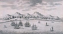
In 1610, Prince Jayawikarta granted permission to Dutch merchants to build a wooden godown and houses on the east bank of the Ciliwung River, opposite to Jayakarta.
[13]: 29 The rivalry was ultimately resolved in 1619, when the Dutch established a closer relationship with Banten and militarily intervened at Jayakarta, where they assumed control of the port after destroying the existing city.
[14] The new city built on the site was officially named as Batavia on January 18, 1621,[14] from which the Dutch East Indies eventually ruled the entire region.
[15] During the period, administrative buildings were relocated to the area then known as Weltevreden, e.g. south of the Koningsplein, the Waterlooplein and Rijswijk (Jalan Veteran).
The area, then known as Weltevreden, which include the Koningsplein, Rijswijk, Noordwijk, Tanah Abang, Kebon Sirih, and Prapatan became a popular residential, entertainment and commercial district for the European colonial elite.
A schichoo ("Mayor") was superior to all of these officials, following the law created by the Guisenken ("Head of the Japanese Imperial Administration").
This agency was composed of twelve local Javanese leaders who were regarded as loyal to the Japanese; among them were Suwiryo (who became the vice for Jakarta's schichoo) and Dahlan Abdullah.
[17] After the war, the Dutch name Batavia was internationally recognized until full Indonesian independence was achieved on 27 December 1949 and Jakarta was officially proclaimed the national capital of Indonesia.
On 19 September 1945, Sukarno held his Indonesian independence and anti-colonialism/imperialism speech, during Rapat Akbar or grand meeting at Lapangan Ikada, now the Merdeka Square.
[21] AT that time, Jalan Sudirman was largely rural and devoid of any buildings until the 1970s, with the exception of Gelora Bung Karno sports complex.
Only in late 1957, the nationalization of Dutch assets would begin, partly triggered by the anger over the refusal of the Netherlands to transfer sovereignty of Irian Jaya to Indonesia.
[25] The departure of the Dutch also caused a massive migration of the rural population into Jakarta, in response to a perception that the city was the place for economic opportunities.
Instead, the city's boundaries were expanded, and it became the Daerah Khusus Ibukota (DKI, Special Capital Territory), one of the provinces of Indonesia.
The event was used as a trigger to complete new landmarks in Jakarta, i.e. Gelora Bung Karno Sports Complex, and so the first half of the 1960s saw large government-funded projects that were undertaken with openly nationalistic architecture.
[23] By working on the optimistic monumental projects, Sukarno hoped to put the newly independent nation's pride on international display.
Some of the notable monumental projects of Sukarno during the first half of the 1960s were: Semanggi "clover-leaf" highway interchange, a broad avenue in Central Jakarta (Jalan M.H.
Jalan Sudirman was still relatively empty, except for the Gelora Bung Karno sports complex and some housing at Bendungan Hilir and Setiabudi.
The investment of overseas capital into joint-venture property and construction projects with local developers brought many foreign architects into Indonesia.
As a result, downtown areas in Jakarta gradually resembled those of the large Western cities; and often at a high environmental cost: high-rise buildings consume huge amounts of energy in terms of air-conditioning and other services.
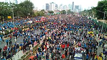
The city became a center of violence, protest, and political maneuvering, as long-time president, Suharto, began to lose his grip on power.
Tensions reached a peak in May 1998, when four students were shot dead at Trisakti University by security forces; four days of riots ensued, resulting in damage to, or destruction of, an estimated 6,000 buildings, and the loss of 1,200 lives.
[35] In the following years, including several terms of ineffective presidents, Jakarta was a center of popular protest and national political instability.