History of Mexico City
1325 C.E as the Mexica city-state of Tenochtitlan, which evolved into the senior partner of the Aztec Triple Alliance that dominated central Mexico immediately prior to the Spanish conquest of 1519–1521.
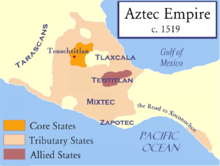
[2] At its height, just before the Spanish arrived, Tenochtitlan was the center of the vast Aztec Empire, stretching from the Atlantic to Pacific coasts and south towards the Yucatán Peninsula and Oaxaca.
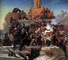
While the Spaniards marveled at the city's artifacts and strange foods, they were horrified by the religious rites involving human sacrifice and, being vastly outnumbered, Cortes worried greatly that Moctezuma was plotting to destroy him.
However, the emperor decided not to appoint him as governor of New Spain but instead to grant him the noble hereditary title of Marquis of the Valley of Oaxaca, with vast numbers of tributary indigenous people there and elsewhere.
[34] After the conquest, the Spaniards generally left the existing Nahua city-states or altepetl largely intact, but Mexico City was an exception since it became the seat of Spanish political power.
[34] Even though prehispanic Tenochtitlan-Tlatelolco was built on an island in the middle of the major lake system, they had political power over holdings on the mainland, a standard pattern of scattered rather than compact settlement and rule.
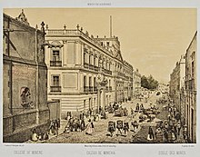
In addition to the Cathedral, there were the bell towers and cupolas of Santa Teresa la Antigua, the College of Saints Peter and Paul and the chapel of San Felipe Neri as landmarks.
Its prestige as representing civilization allowed the colonial system to function during the long period from the 1640s to the 1760s when crown authorities in Mexico City were too weak politically to regulate much of the economic activities over such a vast territory.
[48] He was also concerned that the prior cult of Quetzalcoatl would find its way into the new religion by equating this god with the Apostle Thomas, as an earlier attempt to evangelize the indigenous people before the Spanish conquest.
Public hangings and even burnings, not unusual in Europe at the time, were also used in New Spain, especially in Mexico City, as demonstrations of the joint power of the Church and the State over individual actions and social status.
The consulado was founded in Mexico City in 1594, controlled by peninsular wholesale merchants who dealt in long-distance trade, who often married into local elite families with commercial ties.
[52] In the eighteenth century, as New Spain's economy boomed, consulados were established in the port of Veracruz and in Guadalajara Mexico, indicating increased trade and the expansion of the merchant elite.
[56] Since Mexico City was the hub of so much sustained economic activity, the capital also attracted large numbers of skilled artisans, who often organized themselves into guilds to protect their monopoly on production for a relatively small market.
Nephews, other relatives and friends formed broad networks of interest over a wide geographical area from the capital cities into the countryside and through the span of economic activities.
The Aguayos left these estates in the hands of administrators, backed by armed guards to ward off indigenous attack, to live off the revenues in Mexico City, where they possessed four palatial residences.
The establishment of the Nacional Monte de Piedad, the pawnshop still in operation in modern Mexico City, allowed urban dwellers who had any property at all to pawn access to interest-free, small-scale credit.
Another eighteenth-century example of private philanthropy that then became a crown institution was the ‘'Hospicio de Pobres'’, the Mexico City Poor House, founded in 1774 with funds of a single ecclesiastical donor, Choirmaster of the Cathedral, Fernando Ortiz Cortés, who became its first director.
Revillagigedo focused special attention on cleaning up the Plaza Mayor and the viceregal palace, removing pulque stalls, garbage, wandering dogs, cows, and pigs, moved the market area elsewhere.
[83][84] As Mexico experienced a series of droughts and bad harvests in the eighteenth century, the crown set up granaries (alhóndigas) to store wheat and corn so that the price of basic staples did not soar for the urban poor.
Mexico City had experienced two major riots in the seventeenth century, one in 1624 that ousted the viceroy who attempted to eliminate excessive profits for grain and other goods by creole traders.
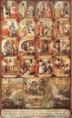
[96] Non-Indians (‘'gente de razón'’, a category that included Spaniards, mestizos, mulatos, and other mixed-race castas) were arrested for financial crimes (gambling, debt), tavern violations, family offenses, vagrancy, and disorderly conduct.
[98] When rebellion against Spanish rule broke out, interests outside of Mexico City would be represented by Father Miguel Hidalgo y Costilla, José María Morelos and others.
[4] To end the war officially, American and Mexican representatives met at the Villa of Guadalupe Hidalgo, across from the shrine of the patron saint of Mexico, in what is now the far north of the city.
With the ouster of the imperial French in 1867 and return to Mexico City of republican president Benito Juárez, the avenue was initially renamed Calzada Degollado and then in 1872 changed to Paseo de la Reforma.
With the ouster of the French occupiers and the political exile of their conservative Mexican supporters, liberalism put its stamp on Mexico City in the form of new monuments and the renaming of streets.
Madero and Pino Suárez returned to the Palace to address the crisis, calling in reserves from other military academies and the forces of Felipe Ángeles in Cuernavaca to assist in defense.
Many street names were changed to commemorate the deeds of revolutionary heroes, including Francisco Madero, José María Pino Suárez, whose democratically elected government was overthrown by military coup in 1913.
In the first decades of the 20th century, the city extended north to the Río de Consulado, east to Metro Jamaica, west to Chapultepec and south to roughly were the Secretariat of Communications and Transportation building at Xola is now.
There had been proposals for a subway system dating back decades, but political forces in favor of car owners (middle class and elites) blocked the plans for underground mass transit.
Growth pushing of the edges of this reserve has been causing both economic and political struggles which include fraudulent real estate schemes, illegal development of ejidal property, along with popular resistance and opposition movements.