History of Norfolk
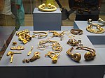
Communities have existed in Norfolk since the last Ice Age and tools, coins and hoards such as those found at Snettisham indicate the presence of an extensive and industrious population.
The Iceni tribe inhabited the region prior to the Roman conquest of Britain in 43 AD, after which they built roads, forts, villas and towns.
With steady growth and strong overseas links it became an important mediaeval city, but it suffered from internal tensions, unsanitary conditions and disastrous fires.
[7] A find at Sutton (near Stalham) on 7 July 1875 revealed a copper alloy shield buried under peat lying on, and covered by, white sand.
After Boudica was humiliated and her daughters raped she led a rebellion in which the towns of Colchester (Camulodunum), London (Londinium) and St. Albans (Verulamium) were sacked.
Following the defeat of Boudicca the Romans restored order on the region by establishing an administrative centre at Venta Icenorum (the present Caistor St. Edmund), a small town built at Brampton and other settlements which were developed at river crossings or road junctions.
[16] Around 410 AD, Germanic-speaking settlers began to arrive from north-west Europe, thus placing the first phases of the Anglo-Saxon settlement of Norfolk before the supposed landing of Hengist and Horsa in Kent in 449.
The migration here likely occurred on a very large scale; however, archaeologist Toby Martin has stressed that the settlers did not arrive as part of a coherent tribal group, and that the self-identification of the people of the region as Angles seems to have emerged from a later period of ethnogenesis.
[19] Excavations and place-name evidence indicates that the early Anglo-Saxons (pre-800 AD) seem to have occupied the south and south-west of Norfolk most densely, with settlements concentrated along river systems.
A settlement and a cemetery at Spong Hill, containing both graves and inhumation pots, is an example of one of the earliest Anglo-Saxon sites to have been found in Norfolk.
[19] During the 7th century East Anglia adopted Christianity and the custom of burying grave goods, found at numerous sites, eventually ceased.
Evidence of early Anglo-Saxon settlement exists in the form of Ipswich ware pottery and coins (sceattas) that are unique to the period.
By 850 AD the majority of the county's current pre-Danish placenames had been created, although only two names – Deorham (modern West Dereham) [20] and Cnobheresburgh (the site of an unidentified monastery on the east coast) – exist in early Anglo-Saxon documents.
As punishment, the main anarchists were put to death and the city lost its liberties and was forced to pay for the building of a new gate for the priory.
The area enclosed was the largest for any city in England, although inside was a considerable amount of pasture land, which was slowly absorbed as new monastic settlements, houses, markets and industrial sites appeared.
Extensive remains of several religious houses can be seen around Norfolk, such as at North Creake, Binham, Little Walsingham, Castle Acre and Thetford Priory.
John of Oxnead is the first chronicler to record the major floods that recurred during this period, as the sea breached the vulnerable east coast and devastated the land.
As a result of flooding, the extraction of peat declined and the records change from peat-digging accounts to descriptions of fen, marsh, fisheries and the importing of sea-coal from the north-east of England.
After the enclosures of local landowners around Norfolk were destroyed, thousands of people joined Robert Kett in a march on Norwich, forming a large organised camp at Mousehold Heath in July 1549.
In London, the government responded to the crisis by sending the Marquess of Northampton to regain Norwich, who initially entered the city unopposed, but was forced by the rebels to withdraw with his army to Cambridge.
Near the public cross all these monuments of idolatry must be sacrificed to the fire..." [39] The only serious fighting in Norfolk during the civil war was at King's Lynn, where Royalist sympathies were strongest.
In 1647 the city's citizens elected John Utting, an act that angered local Puritans, who managed to obtain orders for him to be detained in London.
There followed a period of great confusion, during which time rioters attached the homes of leading Puritan aldermen and that of Sheriff Thomas Ashwell.
A small contingent of Parliamentary troops arrived and managed to gain entry into the city, leading to running battles along St. Stephens street.
During this confused period, rioters who had taken possession of the armory contained in the Royalist Committee House on Bethel Street accidentally ignited the barrels of black powder stored there, leading to a tremendous explosion causing immense destruction to the city and great loss of life.
In the middle of the 19th century, over a hundred Norfolk families owned estates greater than 2,000 acres (8.1 km2; 3.1 sq mi) in size, and there were numerous smaller landowners in the county.
After 1875, a long depression in English agriculture and industry set in, which reduced estate incomes and put severe pressure on their owners,[46] a situation made worse by the accumulation of debts due to family settlements or extravagant expenditure, often sustained over generations, and the introduction of Death Duties in 1894.
A housing boom during the 1890s driven by a dramatic increase in Norfolk's population enabled some landowners on the outskirts of towns and coastal resorts to profit from the sale of their land.
The war was the first time that significant aviation activity spread throughout the county with a large number of aerodromes and landing grounds being built.
As well as Boulton and Paul, the firm of Lawrence Scott & Electromotors was also involved in the war effort, providing shells as well as electrical motors and other components for the Navy.