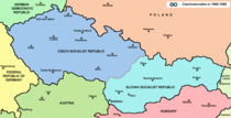
History of Slovakia
[17] The development of the Hunnic Empire in the Eurasian Steppes forced large groups of Germanic peoples, including the Quadi and the Vandals, to leave their homelands by the Middle Danube and along the upper course of the river Tisza in the early 5th century.
He also writes that the Slavs, who remained "an independent third party" in strained Longobard-Gepid relations, were not interested in conflicts with their Germanic neighbours, but made raids in the faraway Byzantine Empire.
[54] In the 670s, the new population of the "griffin and tendril" archaeological culture appeared in the Pannonian Basin expelling Kuber's Bulgars south out of Sirmium (the westernmost part of Kubrat's Onoguria).
Higher productivity initiated changes in the Slavic society, released a part of human resources previously required for farming and allowed to form groups of professional warriors.
[64] The Conversio Bagoariorum et Carantanorum, written around 870, narrates that Moimir, the leader of the Moravians, expelled one Pribina, forcing him to cross (or come up) the Danube and join Radbod, who was the head of the March of Pannonia in the Carolingian Empire from around 830.
[67][66] Three of the eleven extant copies of the Conversio also contain an out of context statement which says that Adalram, who was Archbishop of Salzburg between 821 and 836, had once consecrated a church on Pribina's "estate at a place over the Danube called Nitrava".
However, according to Třeštík, this information can be explained as a reasonable mistake of the Frankish bishops who knew that the territory was in the past a separate "regnum" different from Moravia and because it was ruled by Svatopluk I, they incorrectly assumed that he also conquered it.
Although some contemporary sources mention that Great Moravia disappeared without trace and its inhabitants left, archaeological research and toponyms suggest the continuity of Slavic population in the river valleys of the Inner Western Carpathians.
Between 930 and 940, larger groups of Magyars began to migrate to the southern parts of today's Slovakia, but did not cross the line Bratislava, Hlohovec, Nitra, Levice, Lučenec, Rimavská Sobota.
In southern Slovakia, the Hungarians frequently founded their villages close to the older Slavic settlements as they changed their nomadic lifestyle and settled; they occasionally joined them and used the same cemeteries.
[103][page needed] The development of the future Kingdom of Hungary started during the reign of Grand Prince Géza (before 972–997) who expanded his rule over the territories of present-day Slovakia west of the River Garam / Hron.
[62][109] On the other hand, historians have not reached a consensus on this subject; e.g., it is still being debated whether the formation of the basic unit of the administration (vármegye) in the kingdom followed foreign ( Frankish, Bulgarian, Moravian or Ottonian) patterns or it was an internal innovation.
[119] The history of the Tercia pars regni ended in 1107, when King Coloman of Hungary occupied its territories taking advantage of the pilgrimage of Duke Álmos (his brother) to the Holy Land.
[120] Although, Duke Álmos, when returned to the kingdom, tried to reoccupy his former duchy with the military assistance of Henry V, Holy Roman Emperor, but he failed and was obliged to accept the status quo.
[123] Bohumír (Bogomer), the župan of Trenčín who played an important role in the suppression of Austrian units, later led the army send to help Bolesław V the Chaste (son-in-law of the Hungarian king) attacked by Konrad I of Masovia.
[129][130][131] The list of towns with the earliest charters contains Spišské Vlachy (1243), Košice (before 1248), Nitra (1248), Banská Štiavnica (1255), Nemecká Ľupča (1263), Komárno (1269), Gelnica (before 1270), Bratislava (1291) and Prešov, Veľký Šariš and Sabinov (all in 1299).
[133] The colonisation of the northern parts of the Kingdom of Hungary continued during the period; Walloon, German, Hungarian and Slavic "guests" (hospes, as they are called in contemporary documents) arrived to the scarcely populated lands and settled down there.
[122][136] In that time, there already existed settlements with a relatively highly developed economy in the territory of present-day Slovakia,[137] but Germans who came from economically and administrative more advanced regions introduced new forms of production and management, new legal system and culture.
[138] According to the decree of the King Vladislaus II Jagiello (1498) six of the ten most important towns in the kingdom were located in the present-day Slovakia: Košice, Bratislava, Bardejov, Prešov, Trnava and Levoča.
[154] He allied himself with the murdered Amade Aba's sons against Košice, but King Charles I of Hungary, who had managed to acquire the throne against his opponents, gave military assistance to the town and the royal armies defeated him at the Battle of Rozgony / Rozhanovce in 1312.
However, the Privilegium pro Slavis, dated to 1381, attests notably to nation-building in the wealthy towns: King Louis I gave the Slavs half of the seats in the municipal council of Žilina.
Many of the towns (e.g., Banská Bystrica, Bratislava, Košice, Kremnica and Trnava) received the status of "free royal cities" (liberæ regiæ civitates) and they were entitled to send deputies to the assemblies of the Estates of the Kingdom from 1441.
[164] King Sigismund (1387–1437) granted vast territories to his followers (e.g., to the members of the Cillei, Rozgonyi and Perényi families) during his reign; one of his principal advisers, the Polish Stibor of Stiboricz styled himself "Lord of the whole Váh" referring to his 15 castles around the river.
[166] The Dowager Queen Elisabeth hired Czech mercenaries led by Jan Jiskra who captured several towns on the territory of present-day Slovakia (e.g., Kremnica, Levoča and Bardejov) and maintained most of them until 1462 when he surrendered to King Matthias Corvinus.
The heyday of the movement came to a sudden end after 1867, when the Habsburg domains in central Europe underwent a constitutional transformation into the dual monarchy of Austria-Hungary as a result of the Austro-Hungarian Compromise of 1867.
As a result of the counter-attack of the Hungarian Red Army in May–June, 1919, Czech troops were ousted from central and eastern parts of present Slovakia, where a puppet short-lived Slovak Soviet Republic with its capital in Prešov was established.
Concern among other Warsaw Pact governments that Dubček had gone too far led to the invasion and occupation of Czechoslovakia on 21 August 1968, by Soviet, Hungarian, Bulgarian, East German, and Polish troops.
In the September 2002 parliamentary election, a last-minute surge in support for Prime Minister Dzurinda's Slovak Democratic and Christian Union (SDKÚ) gave him a mandate for a second term.
The election in June 2010 was won by Smer with 34.8% but Fico was unable to form a government, so a coalition of SDKU, KDH, SaS and Most-Hid took over, with Iveta Radičová as the first woman prime minister.
[194] In September 2023, populist left-wing Smer-SSD, led by former prime minister Robert Fico, won the general election, taking 79 seats in a 150-seat parliament with its allies, the centre-left Hlas and nationalist SNS parties.