History of South India
Karikala Chola (late 1st century CE) was the most famous king during the early years of the dynasty and managed to gain ascendency over the Pandyas and Cheras.
This period coincided with the ascendency of the Kalabhras who moved down from the northern Tamil country, displacing the established kingdoms and ruled over most of southern India for almost 300 years.
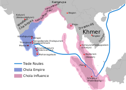
Rajendra Chola I completed the conquest of Sri Lanka, invaded Bengal, and undertook a great naval campaign that occupied parts of Malaya, Burma, and Sumatra.
The Early Cheras ruled over the Malabar Coast, Coimbatore, Erode, Namakkal, Karur and Salem Districts in South India, which now form part of the modern day Indian states of Kerala and Tamil Nadu.
Throughout the reign of the Early Cheras, trade continued to bring prosperity to their territories, with spices, ivory, timber, pearls and gems being exported to the Middle East and to southern Europe.
The contact with Middle East and Romans might have given rise to small colonies of Cochin Jews, Mappila Muslims, and Syrian Christians in the chief harbour towns of Kerala.
The great Satavahana emperors Gautamiputra Satakarni and Sri Yajna Sātakarni repulsed foreign invasions from the likes of the Western Kshatrapas and stopped their expansion.
Pallavas started their rule from Krishna River valley, known today as Palnadu, and subsequently spread to present-day southern Andhra Pradesh and northern Tamil Nadu.
[24] The era witnessed also a shift in political power, evidenced by a gradual increase of Namboothiri Brahmin settlements, who established the caste hierarchy in Kerala by assigning different groups separate positions.
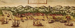
[37][38] The port at Kozhikode held the superior economic and political position in Kerala, while Kollam (Quilon), Kochi, and Kannur (Cannanore) were commercially confined to secondary roles.
The empire reached its zenith under Ganapatideva who was its greatest ruler, responsible for uniting the upper and lower regions of eastern Deccan that spoke the Telugu language, for the first time.
It was made possible due to extensive building of irrigation tanks, artificial lakes and other kinds of small and large reservoirs, interconnected through linking techniques, which helped in converting the dry, arid and rugged areas of Kakatiya territory into a strong, wealthy and stable abode for people who migrated and settled in Telangana.
Their encouragement of inland and maritime trade with safety incentives and exemptions for merchants who faced loss in their sea-borne journey greatly developed commerce with other nations and faraway kingdoms, bringing vast amounts of riches.
The ancient kingdom of Ezhimala in Northern Kerala had jurisdiction over the North Malabar which consisted of two Nadus (regions)- The coastal Poozhinadu and the hilly eastern Karkanadu.
[46] It is said that Nannan, the most renowned ruler of Ezhimala dynasty, took refuge at Wayanad hills in the 5th century CE when he was lost to Cheras, just before his execution in a battle, according to the Sangam works.
[46] Ezhimala kingdom was succeeded by Mushika dynasty in the early medieval period, most possibly due to the migration of Tuluva Brahmins from Tulu Nadu.
The Kolathunadu in the late medieval period emerged into independent 10 principalities i.e., Kadathanadu (Vadakara), Randathara or Poyanad (Dharmadom), Kottayam (Thalassery), Nileshwaram, Iruvazhinadu (Panoor), Kurumbranad etc., under separate royal chieftains due to the outcome of internal dissensions.
[57] The Koyilandy Jumu'ah Mosque in the erstwhile Kolathunadu contains an Old Malayalam inscription written in a mixture of Vatteluttu and Grantha scripts which dates back to the 10th century CE.
Prolaya Vema Reddy was part of the confederation that started a movement against the invading Turkic Muslim armies of the Delhi Sultanate in 1323 CE and succeeded in repulsing them from Warangal.
[62] Irrespective of their origin, historians agree the founders were supported and inspired by Vidyaranya, a saint at the Sringeri monastery to fight the Muslim invasions of southern India.
[5][63] Writings by foreign travelers during the late medieval era combined with recent excavations in the Vijayanagara principality have uncovered much-needed information about the empire's history, fortifications, scientific developments and architectural innovations.
In the first two decades after the founding of the empire, Harihara I gained control over most of the area south of the Tungabhadra river and earned the title of Purvapaschima Samudradhishavara ("master of the eastern and western seas").
By 1374 Bukka Raya I, successor to Harihara I, had defeated the chiefdom of Arcot, the Reddys of Kondavidu, the Sultan of Madurai and gained control over Goa in the west and the Tungabhadra-Krishna River doab in the north.
[83][84] Tirumala Deva Raya was succeeded by his son Sriranga I later followed by Venkata II who was the last monarch of Vijayanagara empire, made his capital Chandragiri and Vellore, repulsed more invasions from the Deccan Sultanates and saved Penukonda from being captured.
Narayanan, a Kerala-based historian, in his book, Calicut: The City of Truth states that the Eradi was a favourite of the last Later Chera king and granted him, as a mark of favor, a small tract of land on the sea-coast in addition to his hereditary possessions (Eralnadu province).
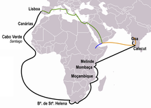
Abdur Razzak (1442–43), Niccolò de' Conti (1445), Afanasy Nikitin (1468–74), Ludovico di Varthema (1503–1508), and Duarte Barbosa witnessed the city as one of the major trading centres in the Indian subcontinent where traders from different parts of the world could be seen.
[99] The most powerful kingdom of Kerala during the colonial period, Travancore, was developed through the expansion of Venad by Mahahrajah Marthanda Varma, a member of the Thrippappur branch of the Ay Dynasty who ascended to the throne in the 18th century.
The Wodeyar kingdom of Mysore, which was originally in tribute to Vijayanagara and gained in strength over the next few decades, subsequently emerging as the dominant power in the southern part of South India.
Following Tipu's death in the fourth war in the siege of Seringapatam (1799), large parts of his kingdom were annexed by the British, which signalled the end of a period of Mysorean hegemony over South India.
South India during the British colonial rule was divided into the Madras Presidency and Hyderabad, Mysore, Thiruvithamcoore (also known as Travancore), Cochin, Vizianagaram and a number of other minor princely states.