Ho Chi Minh trail
[4] The trail was able to effectively supply troops fighting in the south, an unparalleled military feat, given it was the site of the single most intense air interdiction campaign in history.
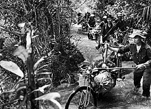
The area through which the system meandered was among the most challenging in Southeast Asia: a sparsely populated region of rugged mountains 500–2,400 metres (1,500–8,000 ft) in elevation, triple-canopy jungle and dense tropical rainforests.
In September 1959, Hanoi established the 559th Transportation Group, headquartered at Na Kai, Houaphan province in northeast Laos close to the border.
It was under the command of Colonel (later General) Võ Bẩm and established to improve and maintain a transportation system to supply the VC insurgency against the South Vietnamese government.
Materiel sent from the north was stored in caches in the border regions that were soon retitled "Base Areas" (BA), which, in turn, became sanctuaries for VC and PAVN forces seeking respite and resupply after conducting operations in South Vietnam.
[10]: 164 The system developed into an intricate maze of 5.5-metre-wide (18 ft) dirt roads (paved with gravel and corduroyed in some areas), foot and bicycle paths and truck parks.
There were numerous supply bunkers, storage areas, barracks, hospitals, and command and control facilities, all concealed from aerial observation by an intricate system of natural and man-made camouflage that was constantly improved.
By 1973, trucks could drive the entire length of the trail without emerging from the canopy except to ford streams or cross them on crude bridges built beneath the water's surface.
Since the road network in the trail system was generally dirt, the bulk of supply transport, and the military efforts that they supported, were conducted during the dry season.
[11]: 97 U.S. Defense Intelligence Agency (DIA) analysts concluded that during the 1965 Laotian dry season the enemy was moving 30 trucks per day (90 tonnes) over the trail, far above the Saigon estimate.
[14][15] On 14 December 1964, the U.S. Air Force's (USAF) "Operation Barrel Roll" carried out the first systematic bombardment of the Hồ Chí Minh Trail in Laos.
[11]: 44 On 20 March 1965, after the initiation of Operation Rolling Thunder against North Vietnam, President Lyndon B. Johnson approved a corresponding escalation against the trail system.
Unlike Laos, the trail in Cambodia was not systematically targeted for defoliation, although more than ten missions were mounted against the Parrot's Beak area, spraying approximately 155,000 litres of Agent Orange.
[5]: 158 A common historical perspective supports the efficacy of the campaigns (despite their failure to halt or slow infiltration), as they did restrict enemy materiel and manpower in Laos and Cambodia.
[3]: 208 That future offensive was launched during the lunar new year Tết holiday of 1968, and to prepare for it, 200,000 PAVN troops, including seven infantry regiments and 20 independent battalions, made the trip south.
The number of supply and maintenance personnel dropped, mainly due to increased use of motor and river transport and mechanized construction equipment.
It was composed of three parts: strings of air-dropped acoustic and seismic sensors collected intelligence on the trail; computers at the Intelligence Collection Center (ICS) in Thailand collated the information and predicted convoy paths and speeds; and an airborne relay and control aircraft which received the signals from the sensors and routed aircraft to targets as directed by the ICS.
[10]: 92 Early in 1969, the pipeline crossed the Lao frontier through the Mu Gia Pass and, by 1970, it reached the approaches to the A Shau Valley in South Vietnam.
[8]: 218 Due to the increased effectiveness of "Commando Hunt", North Vietnamese transportation units usually took to the roads only at dusk with traffic peaking in the early morning hours.
[8]: 218 By the last phase of "Commando Hunt" (October 1970 – April 1972), the average daily number of U.S. aircraft flying interdiction missions included 182 attack fighters, 13 fixed-wing gunships, and 21 B-52s.
[5]: 313 Of all the weapons systems used against the trail, according to the official North Vietnamese history of the conflict, the AC-130 Spectre fixed-wing gunship was the most formidable adversary.
[24]: 20 The Laotian towns of Attapeu and Salavan, at the foot of the Bolaven Plateau were seized by the PAVN during 1970, opening the length of the Kong River system into Cambodia.
By 1968, U.S. Special Forces camps at Khe Sanh and Khâm Đức, both of which were used by MACV-SOG as forward operations bases for its reconnaissance effort, had either been abandoned or overrun.
[citation needed] In early-February 1971, 16,000 (later 20,000) ARVN troops crossed the Laotian border along Route 9 and headed for the PAVN logistical center at Tchepone.
[26][5]: 317–361 Unfortunately for the South Vietnamese, U.S. ground troops were prohibited by law from participation in the incursion, and the U.S. was restricted to providing air support, artillery fire, and helicopter aviation units.
The PAVN first launched massed infantry attacks supported by armor and heavy artillery to crush ARVN positions on the flanks of the main advance.
Although an airborne assault managed to seize Tchepone, it was a useless victory, as the South Vietnamese could only hold the town for a short period before being withdrawn due to attacks on the main column.
The North Vietnamese then launched two further attacks from their base areas in Cambodia, the first aimed to seize Kon Tum in the Central Highlands to cut South Vietnam in two; the second provoked a series of battles in and around An Lộc, the capital of Bình Long Province.
Both North and South Vietnamese were to maintain control in the areas under their influence and negotiations between the two nations, possibly leading to a coalition government and unification, were to take place.
The single oil pipeline that had once terminated near the A Shau Valley now consisted of four lines (the largest 20 cm [eight inches] in diameter) and extended south to Lộc Ninh.