Hokianga
As the last ice age regressed, the dramatic rise in sea level slowly flooded the valley turning it into a tidal saltwater harbour with abundant sheltered deep water anchorages.
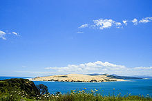
[1] southern right whales possibly frequented the bay historically, prior to significant depletion of the species caused by commercial and illegal hunting.
To the south are the settlements of Waimamaku, Ōmāpere, Opononi, Pakanae, Koutu, Whirinaki, Rawene, Omanaia, Waima, and Taheke; to the north are Broadwood, Pawarenga, Panguru, Mitimiti, and Rangi Point; and at the top of the harbour upstream from the narrows are Horeke, Kohukohu, and Mangamuka.
According to Te Tai Tokerau tradition, Kupe and Ngāhue, the legendary Polynesian navigators and explorers, settled in Hokianga in approximately 925 AD, after their journey of discovery from Hawaiki aboard their waka (canoe) named Matahorua and Tāwhirirangi.
More than a dozen pā sites lie close to the Hokianga, among them notably Motukauri Pã, located on a headland at the end of a tombolo between the Motuti River and Whangapapatiki Creek mouths.
Wesleyan (and, later, Anglican) missionaries were guided along the Ngāpuhi walking tracks to make their own discovery of Hokianga and its accessible timber resources.
Captain James Herd of the Providence[5] responded first, and with missionary Thomas Kendall as guide and translator, crossed the bar and entered the harbour in 1822.
A temporary lull or change in wind direction could cause a sailing ship to lose steerage way and be swept onto the rocky shore.
In 1828, the missionary schooner Herald, built by Henry Williams and sailed by Gilbert Mair, foundered while trying to enter Hokianga Harbour.
[7] In 1837, a French adventurer, the self-titled Baron Charles de Thierry, sailed with 60 settlers into this hive of export activity to claim an immense tract of land that he believed he had purchased 15 years earlier in exchange for 36 axes.
He was eventually granted about 1,000 acres (4 km2) at Rangiahua where he set up his colony, declaring himself "Sovereign Chief of New Zealand", a title that failed to endear him to Ngāpuhi.
Within six days of the Waitangi signing, Governor Hobson, keen to secure full Ngāpuhi support, trekked across to the Māngungu Mission near Horeke where 3000 were waiting.
The relationship between Māori and Pākehā (European) settlers was frequently tense, never more so than during the Dog Tax War of the 1890s, which was largely centred around Hokianga.
Most of the cream delivered to the Motukaraka Dairy Factory was carried there by a fleet of about fifty locally-built launches that criss-crossed the harbour daily, creating in the process a service for both passengers and freight.
On the instructions of Dr George McCall Smith, the Surgeon Superintendent of Rawene Hospital, mounted and armed guards stood at all crossroads to turn back would-be visitors and thus restrict the spread of the disease between settlements.
Attractions such as the great kauri trees of the Waipoua Forest (including the country's largest tree, Tane Mahuta), the historic waterfront villages of Kohukohu and Rawene, cafes, the Horeke basalts, beaches, historic buildings, nature walks, horse trekking, boat trips, and fishing are bringing more visitors every year.
From an early age she showed an interest in local community affairs and politics, and her flair and abilities led to her becoming the undisputed Māori leader of the northern Hokianga by her mid-30s.
Whina Cooper continued to work for the community throughout the 1960s, but it was her 1975 leadership of a hīkoi – a symbolic march – to protest against the loss of Māori land for which she is best remembered.
Opo was a wild dolphin who started following fishing boats around Opononi in early 1955 after her mother had been killed, and would swim daily in the bay close to town.
Unlike the majority of dolphins, she had no qualms about human company, and would perform stunts for locals, play with objects like beach balls and beer bottles, and allow children to swim alongside her and make contact.