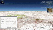
NASA WorldWind
WorldWind allows developers to quickly and easily create interactive visualizations of 3D globe, map and geographical information.
Organizations around the world use WorldWind to monitor weather patterns, visualize cities and terrain, track vehicle movement, analyze geospatial data and educate humanity about the Earth."
[3] The program overlays NASA and USGS satellite imagery, aerial photography, topographic maps, Keyhole Markup Language (KML) and Collada files.
WorldWind.NET provided the ability to browse maps and geospatial data on the internet using the OGC's WMS servers (version 1.4 also uses WFS for downloading place names), import ESRI shapefiles and kml/kmz files.
Other features of WorldWind.NET included support for .X (DirectX 3D polygon mesh) models and advanced visual effects such as atmospheric scattering or sun shading.
Many people using the applications are adding their own data and are making them available through various sources, such as the WorldWind Central or blogs mentioned in the link section below.
All images and movies created with WorldWind using Blue Marble, Landsat, or USGS public domain data can be freely modified, re-distributed, and used on web sites, even for commercial purposes.
Possible types of add-ons: Plugins are small programs written in C#, VB or J# which are loaded and compiled by WorldWind at startup.
These applications include simple virtual globe viewers, satellite tracker, GIS platforms, photo editor, F-16 simulator, mission planning software and many more.