Holyrood Park
It has an array of hills, lochs, glens, ridges, basalt cliffs, and patches of gorse, providing a wild piece of highland landscape within its 650-acre (260 ha) area.
The park was created in 1541 when James V had the ground "circulit about Arthurs Sett, Salisborie and Duddingston craggis" enclosed by a stone wall.
[1] Arthur's Seat, an extinct volcano and the highest point in Edinburgh, is at the centre of the park, with the cliffs of Salisbury Crags to the west.
The hill rises above the city to a height of 251 metres (823 ft), provides excellent views, is quite easy to climb, and is a popular walk.
Salisbury Crags are a series of 46-metre (151 ft) cliffs at the top of a subsidiary spur of Arthur's Seat which rise on the west of Holyrood Park.
Below the foot of the cliffs is a large and steep talus slope falling to the floor of Holyrood Park, with a track running in the space between the two.
[3] Creation of the Radical Road gave easy access to the upper rockface, and infamously the official Keeper of the Royal Park, Charles Hamilton, 8th Earl of Haddington, abused his position to start quarrying the rock face around 1821, causing damage that is still visible.
A report suggested various possibilities: a sky walkway, reopening the path at users' risk, installing shelters or wire mesh, or permanent closure.
[6] James Grant's view of this in 1880 is that it was "an idle story", and quoted Lord Hailes' derivation from Anglo-Saxon meaning "waste or dry habitation".
[8][9] The cliffs are formed from steep dolerite and columnar basalt and have a long history of rock climbing on their faces starting from the earliest days of the sport.
Climbers are now restricted to a designated area of the South Quarry, and need to apply for a permit, free of charge, at the education centre in the north of the park in order to be allowed to climb.
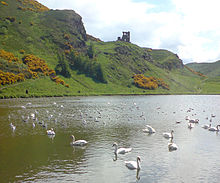
Once a boggy marshland, the loch was formed in 1856 as part of Prince Albert's improvement plans for the area surrounding the palace.
Other geographical features include the Haggis Knowe, Whinny Hill and Hunter's Bog, which drains into St Margaret's Loch.
The ruined Augustinian Abbey of Holyrood was established in 1128, at the order of King David I of Scotland, within his royal deer-hunting park.
[16] In May 1562 Dunsapie Loch was the setting for an entertainment at the wedding of John, Lord Fleming, and Elizabeth Ross, which involved a theatrical recreation of the siege of Leith.
The chapel deteriorated over the years and in 1779, Hugo Arnot in his The History of Edinburgh described it as "a beautiful Gothick building, well suited to the rugged sublimity of the rock ... At its west end there was a tower .. about forty feet high."
It was situated some way to the west of the present cairn with Sir Walter Scott placing it about a furlong to the east of St. Anthony's Chapel.
[24] Scott mentions the cairn several times in the novel, The Heart of Midlothian, by siting Jeanie Dean's tryst with the outlaw, George Robertson, at this spot.
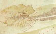
The most dramatic event in the park's history took place on 7 August 1860 when an immense assembly was made of the several Scottish volunteer regiments to appear before Queen Victoria and Prince Albert.
These were designed by a committee including David Octavius Hill, Joseph Noel Paton and W. B. Johnstone (Keeper of the Scottish National Gallery).
Structures included a timber grandstand on the flat ground on the north edge of the park, capable of holding 3000 persons.
[28] Starting at 3pm Queen Victoria first drove by the 21,000 volunteers in an open carriage then sat on the "saluting dais" at the front of the grandstand.
With the crowd then joining the cheer, the huge volume is said to have spooked multiple horses, upon which the various officers were mounted, and there was temporary confusion.
[35] The High Road is now closed to motor vehicles except daytime on Tuesdays, Wednesdays, and Thursdays and for the annual toad migration.
Large and heavy vehicles cause accelerated wearing of roads surfaces and damage kerbs and traffic islands.