San Juan Creek
In addition, urban runoff has changed flow patterns in San Juan Creek and introduced pollutants to the river system.
[7][8][9] At Caspers Wilderness Park, the San Juan Canyon opens up into a fairly wide valley in the foothills of the Santa Ana Mountains.
The creek forms a fresh water lagoon at the northern end of Doheny State Beach, which overflows into Capistrano Bay during periods of high flow.
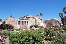
The first recorded earthquake in the area partially destroyed Mission San Juan Capistrano in 1812 (which had been built only six years before), killing forty people in the adobe chapel when it collapsed.
[15][7] Soils in the San Juan watershed are mostly sedimentary rock and are highly erosive, resulting in large alluvial deposits along floodplains.
Soil types in the San Juan watershed can be divided into the Metz-San Emigdio, Sorrento-Mocho, Myford, Alo-Bosanko, Cieneba-Anaheim-Soper, and Friant-Cieneba-Exchequer associations, in order from low to high elevations.
The increase in water flow in San Juan Creek allowed it to maintain its course as an antecedent stream, rather than being diverted to the east or west.
[21] After 1985, the USGS stopped measuring discharge but continues to monitor water level in real-time at the La Novia Street bridge.
[22] According to the city of San Juan Capistrano, the largest flood of record occurred on January 11, 2005 with an estimated discharge of 33,650 cubic feet per second (953 m3/s).
[23] According to the California State Water Resources Control Board (1977) the San Juan Creek Groundwater Basin has a total volume of roughly 900,000 acre-feet (1.1×10⁹ m3).
It has been calculated that a 100-year flood in the watershed would only affect a roughly 0.5 mi (0.80 km) wide area for the lower reaches of San Juan Creek inside San Juan Capistrano, while for Arroyo Trabuco, only a 0.2 mi (0.32 km) wide area would be affected, mainly due to considerable entrenchment of the river bed.
The Bell Creek valley is the least urbanized of the four, being mostly located in the Cleveland National Forest, Starr Ranch Preserve and Caspers Wilderness Park.
Elevation in the Hydrologic Unit ranges from sea level to 5,700 feet (1,700 m) at Santiago Peak (the headwater of Holy Jim Creek, a tributary of Arroyo Trabuco).
Almost all the precipitation occurs between October and April; the average rainfall is 12 to 16 inches (300 to 410 mm), although mountain areas often receive higher amounts.
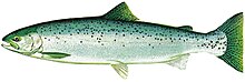
Some streams and ponds host federally listed endangered/threatened species such as tidewater goby, fairy shrimp, and California red-legged frog.
[7] The first European land exploration of Alta California, the Spanish Portolá expedition, passed this way on its way north, camping at San Juan Creek on July 23, 1769.
Franciscan missionary Juan Crespi noted in his diary: "...we came to a very pleasant green valley, full of willows, alders, live oaks, and other trees not known to us.
However, the completion of Interstate 5 through the middle of the San Juan Creek watershed in the 1950s transformed the area into a bedroom community for Los Angeles and permanently erased many remaining grassland, meadow and riparian zones.
As polluted runoff from San Juan Creek continues to flow into the bay, it is trapped for extended periods of time.
At Doheny State Beach, 850,000 annual visitors are exposed to potential health risks from high bacteria levels in the water.
[43] During floods in the 1990s, an almost sheer 30-foot (9.1 m) waterfall appeared on Arroyo Trabuco in northern San Juan Capistrano, threatening the foundations of a railroad bridge.
With an average gradient of 29 percent it has become a major barrier to migrating fish and other riverine organisms, and thus isolates aquatic environments in upper Arroyo Trabuco from the rest of the San Juan watershed.
[30][23] In early 2005, even more severe flooding impacted the San Juan watershed, with an all-time highest flow of 33,650 cubic feet per second (953 m3/s) recorded on January 11.
[23] Also in 2005, pumps were installed on Tick and Dove Creeks (tributaries of Bell Canyon) to remove urban runoff from 1,100-acre (450 ha) of residential areas in eastern Rancho Santa Margarita.
Construction closed the popular San Juan Creek bikeway for two years, inciting protests from many area residents who are frequent users of the path.
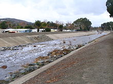
The lower 3.5 miles (5.6 km) of San Juan Creek are channelized between levees, from a point immediately upstream of the Interstate 5 bridge to Doheny Beach.
The USACE describes the San Juan and Arroyo Trabuco levees as providing a "fairly high level of protection currently",[7] though flooding in 1996 and 2005 caused significant damage.
[45] A few check dams exist on small upper tributaries of San Juan Creek, mostly inside the Cleveland National Forest.
[44] A number of drop structures (small dams used to control water velocity and erosion) exist on tributaries of San Juan Creek.
The largest are a 30-foot (9.1 m) cascade immediately downstream of a Metrolink bridge, and a concrete drop structure at the terminus of a culvert that crosses underneath Interstate 5.