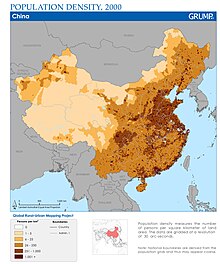
Heihe–Tengchong Line
The origin of the contrast in population density can be found in the favourable climate for agriculture, fertile land and coastal access in eastern China.
The oldest cities in China were located in the southeastern and northeastern regions, such as the Zhongyuan (Central Plains) due to proximity to rivers.
The presence of drainage basins formed by the Yangtze and Yellow River improve crop yield, allowing for population increases.
This imaginary line divides the territory of China as follows (going by 1935 statistics): Despite a large scale urban migration mainly towards coasts but also trending south, 2002 and 2015 statistics remain nearly identical vis-à-vis the line: The major change in area between 1935 and 2015 is attributed to China acknowledging the independence of Mongolia after the Yalta Conference.
However, during the 2000-2015 period, population in the west of the line indeed grew faster than the east, but the growth was not sufficient to budge the rounded percentages.